
Dewdney Trail

The original Dewdney Trail was a 400 km long trail that ran from Hope on the Fraser River in Canada to Galbraith's Ferry on the Kootenay River . The trail was laid and built between 1860 and 1865 under the supervision of engineers Edgar Dewdney and Walter Moberly . The governors of the colony of British Columbia , James Douglas and Frederick Seymour , had commissioned them to do this.
The purpose of the trail was to create a link into interior British Columbia so that the British could maintain control of the increasing gold mining in the area. The second section of the trail took only six months to complete, but many parts were in poor condition. With the advent of other roads and the shift of mining interests to the Columbia Valley , the Dewdney Trail soon lost its importance. In the 1880s the section through the West Kootenays was impassable.
Today one of the better-preserved sections of the trail is a 22-mile stretch that stretches from Christina Lake to Rossland . The British Columbia government has reopened the Dewdney Trail in partnership with private landowners who own 50% of the way through. Portions of the Dewdney Trail in Manning Park are on the Canadian Register of Historic Places .
gallery
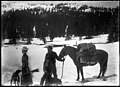
Family on the Dewdney Trail, 1902

Dewdney Trail on the mountain at Manning Park West Gate
.jpg)

Web links
- The Dewdney Trail , Virtual Museum Canada (English, French)
Individual evidence
- ↑ a b c Bart F. Deeg: Dewdney Trail ( English, French ) In: The Canadian Encyclopedia . January 24, 2014. Accessed April 11, 2020.
- ^ Dewdney Trail (Manning Park Sections) ( English, French ) In: Canadian Register of Historic Places . Retrieved April 11, 2020.