
Fontanaccia dolmen

The dolmen of Fontanaccia is located on a slight elevation in the north of the 276 m high Punta Cauria in Sartènais on the French island of Corsica . The Corsicans also call it Stazzona del Diavolu (devil's forge ). In France, dolmen is the generic term for megalithic structures of all kinds (see: French nomenclature ).
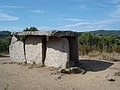
The megalithic complex , which looks like one of the numerous stone boxes that have been taken from the underground and placed on the surface, consists of six vertical stone slabs made of granite and a cover slab weighing more than three tons (3.4 × 2.9 m wide). The chamber is 2.6 m long, 1.6 m wide and 1.8 m high. In 1839 Prosper Mérimée came riding a mule with the mayor of Sartène and scientifically named the complex as a dolmen. He drew it and described it for the Paris Commission des Monuments Historiques . Here he also collected notes on Colomba Carabelli . No grave goods were found in the looted dolmen . Adalbert von Keyserlingk has examined the orientation of the dolmen and put forward theses about a solstice constellation.
- Fontanaccia dolmen

Fontanaccia
Fontanaccia dolmen

Fontanaccia dolmen

Facing south

.jpg)


About 300 m northeast of the dolmen are menhirs from the 2nd millennium BC. To the east stand the stone rows of Stantari and to the southeast those of Renaggiu . Eight statue menhirs represent warriors from the Bronze Age: their swords are carved vertically. A circular route (approx. 2.5 km) leads to all three stations.
literature
- Adalbert Graf von Keyserlingk: And they froze in stone. Early mystery sites in Corsica as the seeds of our time. Verlag Die Pforte, Basel 1983, ISBN 3-85636-066-2 .
- André D'Anna: Sartène - Dolmen de Fontanaccia , in: ADLFI. Archeology de la France - Informations , April 26, 2017. ( online )
Web links
- Dolmen de Fontanaccia in the Base Mérimée of the French Ministry of Culture (French)
Coordinates: 41 ° 31 ′ 46 ″ N , 8 ° 55 ′ 5 ″ E