Dospey Heights
| Dospey Heights | ||
|---|---|---|
|
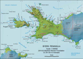
Map of the Byers Peninsula ( Livingston Island ) with Dospey Heights |
||
| Highest peak | Start Hill ( 265 m ) | |
| location | Livingston Island , South Shetland Islands | |
|
|
||
| Coordinates | 62 ° 36 ′ S , 61 ° 8 ′ W | |
The Dospey Heights (English; Bulgarian Доспейски възвишения Dospejski waswischenija ) are unicorn hills on Livingston Island in the archipelago of the South Shetland Islands . On the Ray Promontory of Byers Peninsula , they extend over a distance of 6 km and a width of 2.6 km from Essex Point to the southwest.
British scientists mapped it in 1968, Spanish in 1993. The Bulgarian Commission for Antarctic Geographical Names named it in 2006 after the village of Dospej in southwestern Bulgaria .
Web links
- Dospey Heights in the Composite Gazetteer of Antarctica (English)

