Dueodde
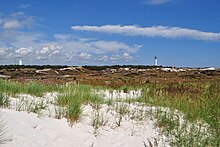
Dueodde [ˈduːoð] is the southeastern tip of Bornholm , where a large coastal dune has formed. This landscape, unusual in view of the island's otherwise rocky coastline, stretches north-east to Snogebæk and west to Boderne. It is under nature protection and is left to the free forces of nature. The name Dueodde means Taubenspitze, Taubenort.
The sandy beach is a bit narrower than on the west coast of Jutland , but the dunes reach similar heights of up to 12 meters. Compared to the North Sea coast , the extreme fore beach lacks the strongly salt and lime-loving plant species. This is explained by the low salinity of the central Baltic Sea (8.0 PSU or 0.8%) and the resulting lack of snail and shell fragments in the sand. At the transition to the dune, there is often felty butterbur , which only occurs in marine life in the Baltic Sea. Common beach grass and its hybrid bastard Baltic beach grass appear as a community. Inland, the brown dunes are almost completely planted with coniferous forest.
history
The sandy areas around Dueodde were planted with beach grass and pine trees for the first time in the 19th century to curb the drift of sand. The fine white sand is also used in hourglasses .
During the Second World War , the German occupiers began building a fortification on Dueodde in autumn 1940. In the following spring, the construction work stalled, so that today only a few concrete foundations are left. Since there were two German listening stations on the east and west coast of Bornholm for testing submarines , shipping and fishing were prohibited in the waters off Dueodde when the weather was appropriate. A V1 rocket , coming from Peenemünde , hit north of Dueodde in the summer of 1943. The Danish officer Chr. Hasager Christiansen was able to photograph the projectile, make a sketch and forward the information to the British. He was arrested and tortured in the course of the German investigation, but could be smuggled over to Sweden . Christiansen received the Distinguished Service Cross for his work .
Swimming and tourism
The well-frequented beach is easily accessible from the parking lot at Fyrvejen . In the vicinity there are three campsites, a youth hostel, the “Granpavillonen” restaurant and a bathing hotel, as well as the Dueslaget kiosk . A holiday home area was built in the adjacent forest area.
Worth seeing
Dueodde Fyr lighthouse on the southern tip is the highest on Bornholm. It was built in 1962 and allows a wide panoramic view. The previous building, the Dueodde Syd beacon, is still right next to the new tower.
The two gun batteries Bornholm South were never completed. The remains are to the right and left of the access road to the youth hostel in the middle of the forest and are freely accessible. While the western battery is well signposted and accessible via a small access road, locating the eastern battery requires some instinct.
Another tower can be seen from afar, which was perceived as an eyesore in this beautiful area until 2015. Hidden behind barbed wire fences, the white tower stretched into the sky of Bornholm in order to listen eastwards for the Danish military and NATO until 2012. This restricted military area and relic of the Cold War has been open to the public as the Museum of the Cold War since July 2015 and advertises with the slogan "Experience Bornholm from a height of 70 m".
literature
Bent Rying (Red.): Bornholm. Shape, history, culture . Wachholtz, Neumünster 1981, ISBN 3-52906172-7 .
Individual evidence
- ↑ Darwin Porter, Danforth Prince, Roger Norum: Frommer's Scandinavia . Lonely Planet, 2009, ISBN 978-1-118-09023-7 , pp. 172 ( Google Books [accessed January 10, 2013]).
- ↑ Bent rying: Bornholm , S. 112th
- ^ Andrew Stone: Scandinavian Europe . Lonely Planet, ISBN 978-1-74104-928-2 , pp. 67 ( Google Books [accessed January 10, 2013]).
- ↑ Listed as Tysk Kanonbatterie WK2 in OpenStreetMap
Web links
Coordinates: 54 ° 59 ′ 13 ″ N , 15 ° 4 ′ 32 ″ E


