
Dumyat
| Dumyat | ||
|---|---|---|
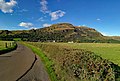
 The Dumyat seen from the southeast |
||
| height | 418 m | |
| location | Stirling , Scotland | |
| Mountains | Ochil Hills | |
| Coordinates | 56 ° 9 '35 " N , 3 ° 52' 40" W | |
|
||
| particularities | westernmost of the Ochil Hills | |

The Dumyat is a hill on the eastern border of the Scottish Council Area Stirling . The 418 m high elevation forms the western end point of the Ochil Hills .
The Dumyat lies north of the flat valley of the Forth and rises abruptly from the south-west. It has a characteristic appearance and shapes the environment. From its top there is a distant view over the Forthtal with the cities of Stirling , Bannockburn , St Ninians and Alloa . The Grampians can be seen when looking north . The Blairlogie settlement is located at the foot of the Dumyat to the south. On the slopes of Dumyat, the remains of the prehistoric Dumyat Fort can be found.

View from Dumyat over the Forthtal

Summit of Dumyat
Dumyat from the south


Web links
Individual evidence
- ↑ Dunmyat. In: Francis H. Groome: Ordnance Gazetteer of Scotland: A Survey of Scottish Topography, Statistical, Biographical and Historical. Volume 2: (Cor - Edn). Thomas C. Jack, Grange Publishing Works, Edinburgh et al. 1884, pp. 439-440.
- ^ Entry in the Gazetteer for Scotland
- ↑ Blairlogie. Stirling. In: David Munro, Bruce Gittings: Scotland. An Encyclopedia of Places & Landscapes. Collins et al., Glasgow 2006, ISBN 0-00-472466-6 .