
Blairlogie (Scotland)
| Blairlogy | |||
|---|---|---|---|
 |
|||
| Coordinates | 56 ° 9 ′ N , 3 ° 53 ′ W | ||
|
|||
| administration | |||
| Post town | STIRLING | ||
| ZIP code section | FK9 | ||
| prefix | 01259 | ||
| Part of the country | Scotland | ||
| Council area | Stirling | ||
| British Parliament | Ochil and South Perthshire | ||
| Scottish Parliament | Clackmannanshire and Dunblane | ||

Blairlogie is a settlement on the eastern border of the Scottish Council Area Stirling and neighboring Clackmannanshire in the traditional Scottish county of Perthshire . It is located about four kilometers northeast of Stirling and six kilometers west-northwest of Alloa at the foot of the Dumyat . Blairlogie is the easternmost of the Hillfoots Villages , a series of villages on the southern slopes of the Ochil Hills and the only one in the Stirling administrative region. It is connected to the road network by the A91 . In 1961 Blairlogie had 70 inhabitants, which means a decrease since 1881 with 94 inhabitants.

Blairlogie at the foot of Dumyat

Blairlogie House
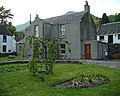
Oldest building in Blairlogie


Web links
Commons : Blairlogie - collection of images, videos and audio files
Individual evidence
- ↑ Blairlogie. In: Francis H. Groome: Ordnance Gazetteer of Scotland: A Survey of Scottish Topography, Statistical, Biographical and Historical. Volume 1: (A - Coru). Thomas C. Jack, Grange Publishing Works, Edinburgh et al. 1882, p. 167.
- ^ Blairlogie Stirling. In: David Munro, Bruce Gittings: Scotland. An Encyclopedia of Places & Landscapes. Collins et al., Glasgow 2006, ISBN 0-00-472466-6 .
- ↑ entry. In: Gazetteer for Scotland. 2011.