Dyleňský les
| Dyleňský les
Tillenberg Forest
|
|
|---|---|
|
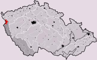
Subunit Dyleňský les (marked in red) |
|
| Highest peak | Dyleň ( 939 m nm ) |
| location | Czech Republic |
| part of | Český les |
| Classification according to | Geomorphological classification of the Czech Republic |
| Coordinates | 49 ° 58 ′ N , 12 ° 30 ′ E |
| surface | 261 km² |
The Dyleňský les (German: Tillenberg Forest) is a sub-unit of the main geomorphological unit Český les (Bohemian Forest) according to the Czech system .
Geomorphological division of the Czech Republic with the main unit Český les (marked in red)
Position and extent
The Dyleňský les is located west of Mariánské Lázně on the Czech-German border and covers an area between Cheb, Mariánské Lázně and Tachov . The highest point is the Dyleň with 939 mnm
To the north joins the Chebská pahorkatina ( Cheb hill country) at Cheb , a sub-unit of the Smrčiny (Fichtelgebirge). Other neighbors are Čerchovský les (Schwarzkopfer Bergland), Kateřinská kotlina (Katharinenbacher Becken) and Přimdský les (Pfraumberg Forest).
Sub- units of the Dyleňský les form the Ž Berárská vrchovina (Brander Uplands ), the Tišinská vrchovina (Rest Uplands), the Třísekerská pahorkatina ( Dreihackener Uplands ) and the Dyleňská hornatina (Tillenberg Uplands).
Geomorphological classification
- System: Hercynian
- Subsystem: Hercynian Mountains
- Main group: Bohemian mass (Česká vysočina)
- Subgroup: Šumava sub-province (Šumavská subprovincie)
- Province: Upper Palatinate Forest Region (Českoleská Oblast)
- Main unit: Upper Palatinate Forest (Český les) (I1A-1)
- Sub-unit: Tillenberg Forest (Dyleňský les)
- Districts: Žďárská vrchovina, Tišinská vrchovina, Třísekerská pahorkatina and Dyleňská hornatina
Individual evidence
- ↑ USHO B3 German (page 5 ff.)
- ↑ DEMEK J. a kol .: Zeměpisný lexikon ČSR - Hory a nížiny, Academia, Praha 1987 s. 222
- ↑ Site plan in Mapy Czech

