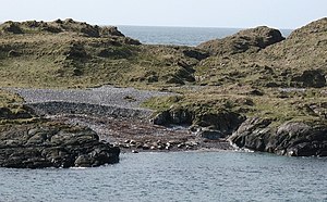
Eilean Mhic Coinnich
| Eilean Mhic Coinnich | ||
|---|---|---|
| View of Eilean Mhic Coinnich | ||
| Waters | Atlantic Ocean | |
| Archipelago | Inner Hebrides | |
| Geographical location | 55 ° 40 ′ 50 ″ N , 6 ° 31 ′ 0 ″ W | |
|
|
||
| length | 660 m | |
| width | 300 m | |
| surface | 17 ha | |
| Residents | uninhabited | |
Eilean Mhic Coinnich (German: MacKenzie Island ) is a small, uninhabited and undeveloped Scottish island that belongs to the Inner Hebrides group. The maximum 660 m long and 300 m wide island is located near the southern tip of the west of the island of Islay peninsula of Rhinns of Islay . It is separated from this by a 100 m wide waterway. Administratively, Eilean Mhic Coinnich belongs to the Council Area Argyll and Bute or historically to the county of Argyllshire . On Islay, Eilean Mhic Coinnich is across from Portnahaven . Together with its neighboring island of Orsay to the east, it protects the port of Portnahaven from the rigors of the Atlantic Ocean .
There is evidence that Eilean Mhic Coinnich was once settled. There are signs of human development in the south-east of the island. Earlier reports about tombs on the island could not be confirmed by recent investigations. The island is declared a nature reserve due to its biodiversity.
In 2008, owner Gilbert MacNab put the island up for sale for £ 100,000. Eventually, school principal Piers Casimir-Mrowczynski of St Albans , Hertfordshire bought the island in 2012 for £ 55,000.
Individual evidence
- ↑ Entry on Eilean Mhic Coinnich in Canmore, the database of Historic Environment Scotland (English)
- ↑ Entry on Eilean Mhic Coinnich in Canmore, the database of Historic Environment Scotland (English)
- ↑ a b Information on islayinfo.com
- ↑ Teacher snaps up uninhabited Iceland , in The Herald , April 19 2012th

