Railway bridge over the Torne river
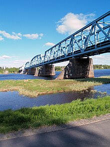
The railway bridge over the Torne älv (or Tornionjoki) is a 405 meter long steel truss bridge with a rotating middle section. As an extension of the Boden – Haparanda railway line, it connects the Swedish city of Haparanda with the Finnish city of Tornio across the border river Torne älv (fin. Tornionjoki ). The side arm Pirkkionjoki / Kirkkopudas is crossed with another steel truss bridge with three openings, each with a 40.2 meter free span.
history
The bridge is the only rail link between Sweden and Finland. As a result of the First World War, it was decided on November 4, 1914 to extend the existing line from Tornio to Karunki in Finland . Because the construction of the Haparadabahn had reached the Swedish Karungi (Finnish spelling of the Swedish place is Karunki ). However, the river was crossed in the conventional way (in summer by ferry, in winter by ice road), although a provisional track was laid over the ice of the Torne älv in winter 1916 for the transport of the Russian imperial mother's saloon car, but as far as known only for this one transport was used. The border traffic between the two Karunki was short-lived, as passenger traffic on the Finnish side ended again in Tornio when the Swedish railway had reached Haparanda. The construction site and execution of this railway bridge was determined in December 1915 by a Finnish-Swedish-Russian engineering commission. Construction began in 1916. On April 1, 1919, the bridge with the line was provisionally put into operation.
Building
The 405-meter-long bridge consists of five approximately 60-meter-long and one approximately 80-meter-long steel lattice parts, they are supported on a total of seven masonry pillars (free span 40-40-60-60-30-30-60-60). The middle of the five 60-meter steel truss parts is supported in the middle on a pillar via a slewing ring, which enables this part of the bridge to be rotated by 90 degrees. As a result, a ship opening can be made between the pillars 4 and 5 and 5 and 6. When open, this part of the bridge is supported on two additional pillars. While the deepest natural river passage was located between pillars 5 and 6, which was considered sufficient, a navigation channel had to be dug between pillars 4 and 5. All piers are equipped on the top of the river with a slope of 1: 1, which is supposed to break the ice when the ice drifts. The pillars are designed as stone-clad concrete pillars that stand on a concrete foundation.
The route is fed to the bridge over dams on both sides. The upper rail of the bridge is 9.73 meters above sea level, while at this point the maximum water mark of the Torne älv is 3.25 meters above sea level and the lowest water mark is −0.13 meters above sea level. On the Swedish side, the bunker system to protect the bridge is still preserved.
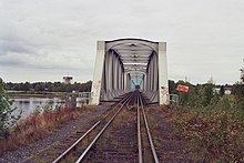
The bridge has a four-rail track with one track for the Finnish broad gauge (1524 mm) and one for standard gauge (1435 mm) interlaced.
The border runs between pillar 5 (pivot point of the rotating bridge part) and pillar 6. The truss parts of the bridge are painted white on the Finnish side and light blue on the Swedish side.
traffic
The bridge is only used by freight trains when required between the two border stations of Tornio and Haparanda. It was used by diesel railcars of the Finnish state railways until 1988. Since then, passenger traffic from Haparanda – Tornio – Kemi has been carried out by road.
The shipping opening is no longer used. Since the closure of the port of Haparanda above the bridge and the construction of a recreational harbor for sailing ships below it, there is no longer any need to open the bridge to ships.
literature
- Mikko Alameri: Railways in Finland. Verlag Josef Otto Slezak, Vienna 1979, ISBN 3-900134-22-7 , description p. 24–25, plans p. 20–21. (Volume 22 of the International Archive for Locomotive History series. )
Web links
Coordinates: 65 ° 49 ′ 40.1 ″ N , 24 ° 8 ′ 58.3 ″ E


