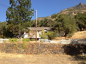
El Portal (California)
| El Portal | ||
|---|---|---|
 The Old El Portal Schoolhouse |
||
| Location in California | ||
|
|
||
| Basic data | ||
| State : | United States | |
| State : | California | |
| County : | Mariposa County | |
| Coordinates : | 37 ° 40 ′ N , 119 ° 47 ′ W | |
| Residents : | 474 (as of April 1, 2010 ) | |
| FIPS : | 06-22328 | |
| GNIS ID : | 2583008 259813, 2583008 | |
El Portal is a statistical community defined in Mariposa County , California , United States . This is located 19.5 km west-southwest of the Yosemite Valley at an altitude of 591 m. According to the 2010 census , 474 people lived in El Portal on this date.
Location and infrastructure
The place is on State Route 140 on the north bank of the Merced River on the western border of Yosemite National Park . The parish is part of the Yosemite National Park administrative district. Public buildings include a post office, community center, and a small school. There are two hotels, a small shop and a gas station in the city.
El Portal is ideal for a variety of outdoor activities and trips to the surrounding national park region.
Until 1945, El Portal was the terminus of the Yosemite Valley Railroad . There is still a turntable and locomotive in front of the old schoolhouse. The name "El Portal" is Spanish and means "the gate".
The first post office in El Portal was opened in 1907.
The National Park Service and several partner organizations have offices in El Portal.


