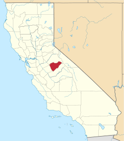
Mariposa County
![Mariposa County Courthouse in Mariposa, listed in NRHP No. 77000306 [1]](https://upload.wikimedia.org/wikipedia/commons/thumb/2/2e/2009-0724-CA-MariposaCH.jpg/298px-2009-0724-CA-MariposaCH.jpg) Mariposa County Courthouse in Mariposa, listed on NRHP No. 77000306 |
|
| administration | |
|---|---|
| US state : | California |
| Administrative headquarters : | Mariposa |
| Address of the administrative headquarters: |
4982 10th Street P.O. Box 247 Mariposa, CA 95338 |
| Foundation : | January 4, 1850 |
| Demographics | |
| Residents : | 18,251 (2010) |
| Population density : | 4.9 inhabitants / km 2 |
| geography | |
| Total area : | 3789 km² |
| Water surface : | 30 km² |
| map | |
| Website : www.mariposacounty.org | |
Mariposa County is a county in the US state of California . The county seat is Mariposa . It is located in the geographic center of California.
history
The county was formed on January 4, 1850 with the other 17 founding counties of California. At the time California was founded, Mariposa County was the largest county. Areas that formerly belonged to Mariposa County are now part of twelve other counties: Fresno County, Inyo County, Kern County, Kings County, Los Angeles County, Madera County, Merced County, Mono County, San Benito County, San Bernardino County, San Luis Obispo County and Tulare County. For this reason, Mariposa County is also known as the "Mother of Counties".
The county's name comes from Mariposa Creek , an area that was given this name by Spanish explorers in 1807 when they encountered a large population of butterflies (Spanish: mariposa = butterfly).
Historical objects
Located in Yosemite National Park on California State Route 41 in Wawona is the historic Wawona Hotel and Pavilion (also known as the Kawona Hotel or Thomas Hill Studio ). The hotel was listed on October 1, 1975 on the National Register of Historic Places with number 75000223. It was also registered as a National Historic Landmark . There are three other National Historic Landmarks in the county . A total of 43 structures and sites in the county are listed on the National Register of Historic Places.
Demographic data
| growth of population | |||
|---|---|---|---|
| Census | Residents | ± in% | |
| 1850 | 4379 | - | |
| 1860 | 6243 | 42.6% | |
| 1870 | 4572 | -26.8% | |
| 1880 | 4339 | -5.1% | |
| 1890 | 3787 | -12.7% | |
| 1900 | 4720 | 24.6% | |
| 1910 | 3956 | -16.2% | |
| 1920 | 2775 | -29.9% | |
| 1930 | 3233 | 16.5% | |
| 1940 | 5605 | 73.4% | |
| 1950 | 5145 | -8.2% | |
| 1960 | 5064 | -1.6% | |
| 1970 | 6015 | 18.8% | |
| 1980 | 11,108 | 84.7% | |
| 1990 | 14.302 | 28.8% | |
| 2000 | 17,130 | 19.8% | |
| 2010 | 18,251 | 6.5% | |
| Before 1900
1900–1990 2000 + 2010 |
|||
According to the 2000 census , Mariposa County had a population of 17,130. There were 6,613 households and 4,490 families. The population density was 5 people per square kilometer. The racial the population was composed of 88.93% White, 0.67% African American, 3.51% Native American, 0.71% Asian, 0.13% Pacific Islander, and 2.67% other races Groups; 3.38% were from two or more races. Hispanic or Latino of any race was 7.76% of the population.
Of the 6,613 households, 25.6% had children and adolescents under the age of 18 living with them. 55.8% were married couples living together, 8.0% single mothers. 32.1% were not families. 26.5% are single households and 11.2% have people aged 65 years or over. The average household size was 2.37 and the average family size was 2.86 people.
The age structure of the county's population was: 21.6% under 18 years, 6.9% 18–24 years, 25.1% 25–44 years, 29.2% 45–64 years and 17.2% 65 years or older. The median age was 43 years. For every 100 females there were 104.7 males, and for every 100 females aged 18 and over there were 105.4 males.
The median income for a household in the county is $ 34,626 , and the median income for a family is $ 42,655. Males had a median income of $ 31,194 versus $ 25,440 for females. The per capita income was $ 18,190. 14.8% percent of the population and 10.5% of families are below the poverty line. 16.5% of them were under 18 years of age and 9.0% were 65 years of age or older.
Places in the county
Census-designated places
Unincorporated communities
Individual evidence
- ^ Extract from the National Register of Historic Places . Retrieved March 5, 2019
- ↑ GNIS-ID: 277286. Retrieved on February 22, 2011 (English).
- ↑ NRIS
- ↑ National Historic Landmarks Program (NHL) ( Memento of the original from June 6, 2011 in the Internet Archive ) Info: The archive link was inserted automatically and has not yet been checked. Please check the original and archive link according to the instructions and then remove this notice.
- ↑ Listing of National Historic Landmarks by State: California . National Park Service , accessed August 27, 2017.
- ↑ Search mask database in the National Register Information System. National Park Service , accessed August 27, 2017.
- ↑ US Census Bureau - Census of Population and Housing . Retrieved March 15, 2011
- ↑ Extract from Census.gov . Retrieved February 28, 2011
- ↑ Extract from census.gov (2000 + 2010). Accessed April 2, 2012
Web links
Coordinates: 37 ° 35 ′ N , 119 ° 55 ′ W


