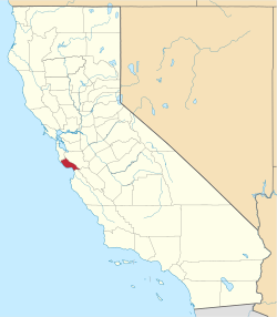
Santa Cruz County, California
| administration | |
|---|---|
| US state : | California |
| Administrative headquarters : | Santa Cruz |
| Foundation : | 1850 |
| Demographics | |
| Residents : | 262,382 (2010) |
| Population density : | 180.5 inhabitants / km 2 |
| geography | |
| Total area : | 1573 km² |
| Water surface : | 119 km² |
| map | |
| Website : www.co.santa-cruz.ca.us | |
Santa Cruz County is a county on the Pacific Ocean in the US state of California . The county seat is Santa Cruz .
history
The county was founded in 1850 when California became a US state. The county was originally called "Branicforte". It was later named after the Santa Cruz Mission. "Santa Cruz" means "holy cross" in Spanish.
Santa Cruz County has two National Historic Landmarks , the California Powder Works Bridge and the Santa Cruz Looff Carousel and Roller Coaster . A total of 45 buildings and sites in the county are listed on the National Register of Historic Places .
geography
The county is located south of the San Francisco Bay Area on the Pacific. It has an area of 1573 square kilometers, of which 419 square kilometers are water surface. It is bordered in a clockwise direction by the following counties: San Mateo County , Santa Clara County , San Benito County, and Monterey County .
Demographics
| growth of population | |||
|---|---|---|---|
| Census | Residents | ± in% | |
| 1850 | 643 | - | |
| 1860 | 4994 | 676.7% | |
| 1870 | 8743 | 75.1% | |
| 1880 | 12,802 | 46.4% | |
| 1890 | 19,270 | 50.5% | |
| 1900 | 21,512 | 11.6% | |
| 1910 | 26,140 | 21.5% | |
| 1920 | 26,269 | 0.5% | |
| 1930 | 37,433 | 42.5% | |
| 1940 | 45.057 | 20.4% | |
| 1950 | 66,534 | 47.7% | |
| 1960 | 84.219 | 26.6% | |
| 1970 | 123,790 | 47% | |
| 1980 | 188.141 | 52% | |
| 1990 | 229.734 | 22.1% | |
| 2000 | 255.602 | 11.3% | |
| 2010 | 262,382 | 2.7% | |
| Before 1900
1900–1990 2000 + 2010 |
|||
According to the 2000 census , Santa Cruz County had a population of 255,602. Of these, 9028 people lived in collective accommodation, the other residents lived in 91,139 households and 57,144 families. The population density was 222 inhabitants per square kilometer. 98,873 residential units were recorded. The racial the population was composed of 75.09 percent white, 0.97 percent African American, 0.96 percent Native American, 3.44 percent Asian, 0.15 percent from the Pacific island area and 15.02 percent from other ethnic groups Groups; 4.37 percent said ancestry from several races. 26.79 percent of the population were of Spanish or Latin American descent, 10.0 percent of German descent, 8.9 percent of English, 8.2 percent of Irish and 6.3 percent of Italian descent.
Of the 91,139 households, 31.9 percent had children or young people living with them. 48.0 percent were married couples living together, 10.2 percent were single mothers, and 37.3 percent were non-families. 25.1 percent were single households and 8.2 percent had people aged 65 years or over. The average household size was 2.71 and the average family size 3.25.
The population was distributed among 23.8 percent under 18 years, 11.9 percent from 18 to 24 years, 30.8 percent from 25 to 44 years, 23.5 percent from 45 to 64 years and 10.0 percent from 65 years or older. The mean age ( median ) was 35 years. For every 100 females there were 99.7 males and for every 100 adult females aged 18 and over there were 97.8 males.
The median income for a household (median) was 53 998 US $ , and the median income for a family $ 61,941. Males had a median income of $ 46,291 versus $ 33,514 for females. The per capita income was $ 26,396. 6.7 percent of families and 11.9 percent of the population lived below the poverty line, including 12.5 percent of residents under the age of 18 and 6.3 percent of residents aged 65 or over.
cities and communes
The number of inhabitants according to the United States Census 2000 in brackets
|
Unincorporated area (1,299.2 km², 45,216 inhabitants) |
Web links
Individual evidence
- ↑ GNIS-ID: 277308. Retrieved on February 22, 2011 (English).
- ↑ Listing of National Historic Landmarks by State: California . National Park Service , accessed August 27, 2017.
- ↑ Search mask database in the National Register Information System. National Park Service , accessed August 27, 2017.
- ↑ US Census Bureau - Census of Population and Housing . Retrieved March 15, 2011
- ↑ Extract from Census.gov . Retrieved February 28, 2011
- ↑ Extract from census.gov (2000 + 2010). Accessed April 2, 2012
- ↑ Santa Cruz County, California , 2000 census data sheet at factfinder.census.gov .
Coordinates: 37 ° 2 ′ N , 122 ° 1 ′ W


