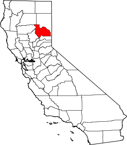
Plumas County
| administration | |
|---|---|
| US state : | California |
| Administrative headquarters : | Quincy |
| Foundation : | 1854 |
| Demographics | |
| Residents : | 20,007 (2010) |
| Population density : | 3 inhabitants / km 2 |
| geography | |
| Total area : | 6769 km² |
| Water surface : | 155 km² |
| map | |
| Website : www.countyofplumas.com | |
Plumas County is a county in the Sierra Nevada Mountains in the state of California in the United States . The county seat is Quincy , the only incorporated city is Portola .
geography
The county has a total area of 6,769 square kilometers. 155 square kilometers (2.29 percent of the total area) are water. It is bordered clockwise by the counties: Lassen County , Sierra County , Yuba County , Butte County , Tehama County, and Shasta County .
history
Nevada County was formed in 1854 from parts of Butte County . Parts of the county were ceded to Lassen County in 1864. It was named after the Feather River , whose Spanish name is Rio de las plumas , which means something like the river of springs.
5 structures and sites in the county are on the National Register of Historic Places .
Demographic data
| growth of population | |||
|---|---|---|---|
| Census | Residents | ± in% | |
| 1860 | 4303 | - | |
| 1870 | 4489 | 4.3% | |
| 1880 | 6180 | 37.7% | |
| 1890 | 4933 | -20.2% | |
| 1900 | 4657 | -5.6% | |
| 1910 | 5259 | 12.9% | |
| 1920 | 5681 | 8th % | |
| 1930 | 7913 | 39.3% | |
| 1940 | 11,548 | 45.9% | |
| 1950 | 13,519 | 17.1% | |
| 1960 | 11,620 | -14% | |
| 1970 | 11,707 | 0.7% | |
| 1980 | 17,340 | 48.1% | |
| 1990 | 19,739 | 13.8% | |
| 2000 | 20,824 | 5.5% | |
| 2010 | 20.007 | -3.9% | |
| Before 1900
1900–1990 2000 + 2010 |
|||
As of the 2000 census , Plumas County had 20,824 people. There were 9,000 households and 6,047 families. The population density was 3 people per square kilometer. The racial the population was composed of 91.78% White, 0.62% African American, 2.55% Native American, 0.53% Asian, 0.10% Pacific Islander, and 1.81% other races Groups; 2.61% were from two or more races. Hispanic or Latino of any race was 5.65% of the population.
Of the 9,000 households, 26.40% had children and young people under the age of 18 living with them. 55.40% were married couples living together, 8.00% were single mothers. 32.80% were not families. 27.50% were single households and 10.10% had someone who was 65 years of age or older. The average household size was 2.29 and the average family size was 2.77 people.
For the entire county, the population was composed of 22.70% of residents under 18 years of age, 6.00% between 18 and 24 years of age, 22.60% between 25 and 44 years of age, 30.80% between 45 and 64 years of age 17.90% were 65 years of age or over. The median age was 44 years. For every 100 females there were 99.80 males, and for every 100 females aged 18 and over there were 97.90 males.
The median income for a household in the 36,351 USD , and the median income for a family was 46,119 USD. Males had a median income of $ 38,742 versus $ 25,734 for females. The per capita income was $ 19,391. 13.10% percent of the population and 9.00% of families are below the poverty line. 16.70% of these were under 18 years of age and 6.40% were 65 years of age or older.
towns and places
- Almanor
- Beckwourth
- Belden
- Blairsden
- Bucks Lake
- C-Road
- Canyondam
- Caribou
- Chester
- Chilcoot Vinton
- Clio
- Crescent Mills
- Cromberg
- Delleker
- East Quincy
- East Shore
- Graeagle
- Greenhorn
- Greenville
- Hamilton Branch
- Indian Falls
- Iron horse
- Johnsville
- Keddie
- La Porte
- Lake Almanor Country Club
- Lake Almanor Peninsula
- Lake Almanor West
- Lake Davis
- Little Grass Valley
- Meadow Valley
- Mohawk Vista
- Paxton
- Plumas Eureka
- Portola
- Prattville
- Quincy
- Spring Garden
- Storrie
- Taylorsville
- Tobin
- Twain
- Valley Ranch
- Whitehawk
Individual evidence
- ↑ GNIS-ID: 277296. Retrieved on February 22, 2011 (English).
- ↑ Search mask database in the National Register Information System. National Park Service , accessed August 27, 2017.
- ↑ US Census Bureau - Census of Population and Housing . Retrieved March 15, 2011
- ↑ Extract from Census.gov . Retrieved February 28, 2011
- ↑ Extract from census.gov (2000 + 2010). Accessed April 2, 2012
Web links
Coordinates: 40 ° 1 ′ N , 120 ° 50 ′ W

