
Mono County
![The Mono County Courthouse, listed on NRHP No. 74000536 [1]](https://de.wikipedia.org/wiki/Datei:Mono_County_Court_House.JPG) The Mono County Courthouse, listed on NRHP No. 74000536 |
|
| administration | |
|---|---|
| US state : | California |
| Administrative headquarters : | Bridgeport |
| Address of the administrative headquarters: |
74 North School Street Bridgeport CA 93517 |
| Foundation : | April 21, 1861 |
| Demographics | |
| Residents : | 14,202 (2010) |
| Population density : | 1.8 inhabitants / km 2 |
| geography | |
| Total area : | 8111 km² |
| Water surface : | 22 km² |
| map | |
 |
|
| Website : www.monocounty.ca.gov | |
Mono County is a county in the US state of California , on the Nevada border . The county seat is Bridgeport .
geography
The county is located in the east of central California under the Sierra Nevada , whose main ridge forms the western border of the county. In the east, the state border with Nevada is also the county border. Geographically it belongs to the Basin and Range region except for the shares in the Sierra Nevada . The valley areas are dry and not very fertile because of the rain shadow of the Bege. The higher elevations are mostly forested, federally owned and part of the Inyo National Forest , a national forest . In the center of the county is the eponymous Mono Lake .
history
Mono County was formed on April 21, 1861 from parts of Calaveras County , Fresno County and Mariposa County . In 1866 parts of Mono County were again annexed to Inyo County .
Mono County has a National Historic Landmark , the Bodie Historic District . Four other structures and sites in the county are on the National Register of Historic Places .
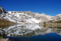
The Greenstone Lake in Mono County
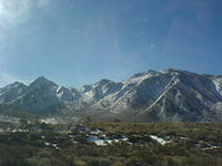
View of the mountains in Mono County from US 395


Municipalities and settlements
Mammoth Lakes is the only separate community in Mono County. The US Census Bureau only differentiates between the north and south of the county. Other settlements have no political self-government, but are recognized by the Geographic Names Information System :
- Aspen Springs
- Belfort
- Benton
- Benton Crossing
- Benton Hot Springs
- Bridgeport
- Chalfant Valley
- Chinatown
- Coleville
- Crestview
- Fales Hot Springs
- Hammil
- June Lake (California)
- June Lake Junction
- Lake Mary
- Lee Vining
- Lower Town
- Lundy
- Mesa Camp
- Mono City
- Montgomery City
- North Landing
- Pizona
- Paradise
- Sonora Junction
- South Landing
- Toms Place
- Upper Town
- Walker
- Whitmore Hot Springs
- Willow Springs
Mono County is also home to Bodie , a touristic ghost town .
Demographic data
| growth of population | |||
|---|---|---|---|
| Census | Residents | ± in% | |
| 1870 | 430 | - | |
| 1880 | 7499 | 1,644% | |
| 1890 | 2002 | -73.3% | |
| 1900 | 2167 | 8.2% | |
| 1910 | 2042 | -5.8% | |
| 1920 | 960 | -53% | |
| 1930 | 1360 | 41.7% | |
| 1940 | 2299 | 69% | |
| 1950 | 2115 | -8th % | |
| 1960 | 2213 | 4.6% | |
| 1970 | 4016 | 81.5% | |
| 1980 | 8577 | 113.6% | |
| 1990 | 9956 | 16.1% | |
| 2000 | 12,853 | 29.1% | |
| 2010 | 14,202 | 10.5% | |
| Before 1900
1900–1990 2000 + 2010 |
|||

According to the 2000 census , Mono County had 12,853 people. There were 5,137 households and 3,143 families. The population density was 2 people per square kilometer. The racial the population was composed of 84.17% White, 0.47% African American, 2.40% Native American, 1.11% Asian, 0.09% Pacific Islander, and 9.51% other races Groups; 2.25% were from two or more races. Hispanic or Latino of any race was 17.69% of the population.
Of the 5,137 households, 28.70% had children and adolescents under the age of 18 living with them. 50.60% were married couples living together, 6.50% were single mothers. 38.80% were not families. 26.60% are single households and 4.30% have someone living there who is 65 years of age or over. The average household size was 2.43 and the average family size was 2.98 people.
For the entire county, the population was composed of 23.00% residents under 18 years of age, 10.30% between 18 and 24 years of age, 33.40% between 25 and 44 years of age, 25.60% between 45 and 64 years of age 7.60% were 65 years of age or over. The median age was 36 years. For every 100 females there were 121.80 males, and for every 100 females aged 18 and over there were 126.80 males.
The median income for a household in the county is $ 44,992 , and the median income for a family is $ 50,487. Males had a median income of $ 32,600 versus $ 26,227 for females. The per capita income was $ 23,422. 11.50 percent of the population and 6.30 percent of families are below the poverty line. 12.20% of these were under 18 years of age and 1.90% were 65 years of age or older.
Web links
- Official website (English)
- Mono County Film and Tourism Commission (English)
Individual evidence
- ^ Extract from the National Register of Historic Places . Retrieved January 14, 2019
- ↑ GNIS-ID: 277290. Retrieved on February 22, 2011 (English).
- ↑ Listing of National Historic Landmarks by State: California . National Park Service , accessed August 27, 2017.
- ↑ Search mask database in the National Register Information System. National Park Service , accessed August 27, 2017.
- ↑ US Census Bureau - Census of Population and Housing . Retrieved March 15, 2011
- ↑ Extract from Census.gov . Retrieved February 28, 2011.
- ↑ Extract from census.gov (2000 + 2010). Accessed April 2, 2012.
List of counties in California
Alameda |
Alpine |
Amador |
Butte |
Calaveras |
Colusa |
Contra Costa |
Del Norte |
El Dorado |
Fresno |
Glenn |
Humboldt |
Imperial |
Inyo |
Core |
Kings |
Lake |
Let |
Los Angeles |
Madera |
Marin |
Mariposa |
Mendocino |
Merced |
Modoc |
Mono |
Monterey |
Napa |
Nevada |
Orange |
Placer |
Plumas |
Riverside |
Sacramento |
San Benito |
San Bernardino |
San Diego |
San Francisco |
San Joaquin |
San Luis Obispo |
San Mateo |
Santa Barbara |
Santa Clara |
Santa Cruz |
Shasta |
Sierra |
Siskiyou |
Solano |
Sonoma |
Stanislaus |
Sutter |
Tehama |
Trinity |
Tulare |
Tuolumne |
Ventura |
Yolo |
Yuba
Coordinates: 37 ° 55 ′ N , 118 ° 52 ′ W