Merced County
![Former Merced County Courthouse, listed on NRHP No. 75000441 [1]](https://upload.wikimedia.org/wikipedia/commons/thumb/d/db/Merced_CA_Historic_Courthouse9.jpg/298px-Merced_CA_Historic_Courthouse9.jpg) Former Merced County Courthouse, listed on NRHP No. 75000441 |
|
| administration | |
|---|---|
| US state : | California |
| Administrative headquarters : | Merced |
| Foundation : | 1855 |
| Made up from: | Mariposa County |
| Demographics | |
| Residents : | 255,793 (2010) |
| Population density : | 51.2 inhabitants / km 2 |
| geography | |
| Total area : | 5107 km² |
| Water surface : | 112 km² |
| map | |
| Website : www.co.merced.ca.us | |
Merced County ( [mərˈsɛd] ) is a county in the center of the US state California . The county seat is Merced .
geography
The county is located north of Fresno and southeast of San José and has a total area of 5,107 square kilometers. Of this, 112 square kilometers are water surfaces (2.19 percent). It is bordered clockwise by the counties: Stanislaus County , Mariposa County , Madera County , Fresno County , San Benito County, and Santa Clara County .
history
Merced County was founded in 1855 from parts of Mariposa County . In 1856 parts were spun off to Fresno County . It takes its name from the Merced River that flows through the county.
15 structures and sites in the county are on the National Register of Historic Places .
Demographic data
| growth of population | |||
|---|---|---|---|
| Census | Residents | ± in% | |
| 1860 | 1141 | - | |
| 1870 | 2807 | 146% | |
| 1880 | 5656 | 101.5% | |
| 1890 | 8085 | 42.9% | |
| 1900 | 9215 | 14% | |
| 1910 | 15,148 | 64.4% | |
| 1920 | 24,579 | 62.3% | |
| 1930 | 36,748 | 49.5% | |
| 1940 | 46,988 | 27.9% | |
| 1950 | 69,780 | 48.5% | |
| 1960 | 90,446 | 29.6% | |
| 1970 | 104,629 | 15.7% | |
| 1980 | 134,560 | 28.6% | |
| 1990 | 178,403 | 32.6% | |
| 2000 | 210,554 | 18% | |
| 2010 | 255.793 | 21.5% | |
| Before 1900
1900–1990 2000 + 2010 |
|||
According to the 2000 census, the population of Merced County was 210,554. There were 63,815 households and 49,775 families. The population density was 42 inhabitants per square kilometer. The racial the population was composed of 56.21% White, 3.83% African American, 1.19% Native American, 6.80% Asian, 0.19% Pacific Islander, and 26.13% other races Groups; 5.65% were from two or more races. Hispanic or Latino of any race was 45.34% of the population.
Of the 63,815 households 45.40% had children and adolescents under the age of 18 living with them. 57.80% were married couples living together, 14.10% were single mothers. 22.00% were not families. 17.70% are single households and 7.40% have someone who is 65 years of age or older. The average household size was 3.25 and the average family size was 3.69 people.
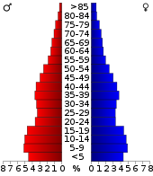
For the entire county, the population was composed of 34.50% residents under 18 years of age, 10.30% between 18 and 24 years of age, 27.90% between 25 and 44 years of age, 17.80% between 45 and 64 years of age 9.50% were 65 years of age or over. The median age was 29 years. For every 100 females there were 99.30 males, for every 100 females aged 18 and over there were 96.60 males.
The median income for a household in the county is $ 35,532 , and the median income for a family is $ 38,009. Males had a median income of $ 31,721 versus $ 23,911 for females. The per capita income was $ 14,257. 21.70% percent of the population and 16.90% of families are below the poverty line. 28.40% of these were under 18 years of age and 10.70% were 65 years of age or older.
towns and places
Individual evidence
- ^ Extract from the National Register of Historic Places . Retrieved March 13, 2011
- ↑ GNIS-ID: 277288. Retrieved on February 22, 2011 (English).
- ↑ Search mask database in the National Register Information System. National Park Service , accessed August 27, 2017.
- ↑ US Census Bureau - Census of Population and Housing . Retrieved March 15, 2011
- ↑ Extract from Census.gov . Retrieved February 28, 2011
- ↑ Extract from census.gov (2000 + 2010). Accessed April 2, 2012
Web links
Coordinates: 37 ° 11 ′ N , 120 ° 43 ′ W


