Placer County
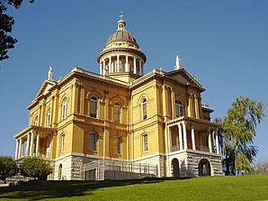
 The Placer County Courthouse in Auburn |
|
| administration | |
|---|---|
| US state : | California |
| Administrative headquarters : | Auburn |
| Foundation : | 1851 |
| Demographics | |
| Residents : | 348,432 (2010) |
| Population density : | 95.8 inhabitants / km 2 |
| geography | |
| Total area : | 3892 km² |
| Water surface : | 255 km² |
| map | |
| Website : www.placer.ca.gov | |
The Placer County is a County in the Sierra Nevada of the US state of California . Because of the ever-expanding metropolitan area of Sacramento, Placer County is one of the fastest growing counties in the United States. The county seat is Auburn .
geography
The county stretches from the suburbs of Sacramento to Lake Tahoe and the US state of Nevada . It has a total area of 3892 square kilometers. Of these, 255 square kilometers (6.55 percent) are water. It is bordered clockwise by the counties: Nevada County , Washoe County , Carson City , Douglas County , El Dorado County , Sacramento County , Sutter County, and Yuba County .
history
Placer County was formed in 1851 from parts of Sutter County and Yuba County . The word placer comes from the combination of the Spanish words plaza de oro , which means place of gold . The county got its name because a lot of gold was mined in this region during the gold rush .
32 structures and sites in the county are on the National Register of Historic Places .
Demographic data
| growth of population | |||
|---|---|---|---|
| Census | Residents | ± in% | |
| 1860 | 13,270 | - | |
| 1870 | 11,357 | -14.4% | |
| 1880 | 14,232 | 25.3% | |
| 1890 | 15.101 | 6.1% | |
| 1900 | 15,786 | 4.5% | |
| 1910 | 18,237 | 15.5% | |
| 1920 | 18,584 | 1.9% | |
| 1930 | 24,468 | 31.7% | |
| 1940 | 28,108 | 14.9% | |
| 1950 | 41,649 | 48.2% | |
| 1960 | 56,998 | 36.9% | |
| 1970 | 77,306 | 35.6% | |
| 1980 | 117,247 | 51.7% | |
| 1990 | 172,796 | 47.4% | |
| 2000 | 248.399 | 43.8% | |
| 2010 | 348,432 | 40.3% | |
| Before 1900
1900–1990 2000 + 2010 |
|||
As of the 2000 census , Placer County had a population of 248,399. There were 93,382 households and 67,701 families. The population density was 68 inhabitants per square kilometer. The racial the population was composed of 88.59% White, 0.82% African American, 0.89% Native American, 2.95% Asian, 0.16% Pacific Islander, and 3.39% other races Groups; 3.21% were from two or more races. Hispanic or Latino of any race was 9.67% of the population.
Of the 93,382 households, 35.30% had children and young people under the age of 18 living with them. 59.40% were married couples living together, 9.20% were single mothers. 27.50% were not families. 21.30% are single households and 8.10% have someone who is 65 years of age or older. The average household size was 2.63 and the average family size was 3.06.
For the entire county, the population was composed of 26.50% residents under 18 years of age, 6.90% between 18 and 24 years of age, 29.00% between 25 and 44 years of age, 24.50% between 45 and 64 years of age 13.10% were 65 years of age or over. The median age was 38 years. For every 100 females there were 96.40 males, and for every 100 females aged 18 and over there were 93.90 males.
The median income for a household in the city was $ 57,535 , and the median income for a family was $ 65,858. Males had a median income of $ 50,410 versus $ 33,763 for females. The per capita income was $ 27,963. 5.80% percent of the population and 3.90% of families are below the poverty line. 6.30% of them were under 18 years of age and 3.80% were 65 years of age or older.
towns and places
Individual evidence
- ↑ GNIS-ID: 277295. Retrieved on February 22, 2011 (English).
- ↑ Search mask database in the National Register Information System. National Park Service , accessed August 27, 2017.
- ↑ US Census Bureau - Census of Population and Housing . Retrieved March 15, 2011
- ↑ Extract from Census.gov . Retrieved February 28, 2011
- ↑ Extract from census.gov (2000 + 2010). Accessed April 2, 2012
Web links
Coordinates: 39 ° 4 ′ N , 120 ° 44 ′ W


