Auburn, California
| Auburn | ||
|---|---|---|
 |
||
| Location in California | ||
|
|
||
| Basic data | ||
| Foundation : | 1849 | |
| State : | United States | |
| State : | California | |
| County : | Placer County | |
| Coordinates : | 38 ° 53 ′ N , 121 ° 5 ′ W | |
| Time zone : | Pacific ( UTC − 8 / −7 ) | |
| Residents : | 13,300 (as of 2010) | |
| Population density : | 696.3 inhabitants per km 2 | |
| Area : | 19.2 km 2 (approx. 7 mi 2 ) of which 19.1 km 2 (approx. 7 mi 2 ) is land |
|
| Height : | 374 m | |
| Postcodes : | 95602-95604 | |
| Area code : | +1 530 | |
| FIPS : | 06-03204 | |
| GNIS ID : | 1657964 | |
| Mayor : | Cheryl Maki | |
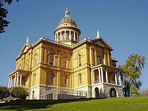
 Auburn Courthouse (local court) |
||
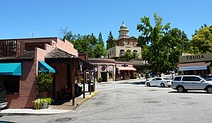
Auburn is a city in Placer County in the US state of California , with about 13,300 inhabitants (the 2010 census ). Auburn is also the seat of the county government . The urban area covers an area of 19.2 square kilometers.
The city was founded in 1849 and is surrounded by the dense coniferous forests of the Sierra Nevada , 50 kilometers northeast of Sacramento on Interstate 80 . In 1853, Auburn became the seat of county government. The foundation stone for the government building, which can be seen from Interstate 80 , was laid on July 4, 1894.
The restored old town offers houses from the middle of the 19th century as a special eye-catcher. The oldest fire station and post office in the service of California are special attractions from the gold rush era .
Ancient gold digger accessories and Native American / Chinese artefacts can be admired at the Placer County Museum .
sons and daughters of the town
- Ben Nighthorse Campbell (born 1933), politician
- Tomas Arana (* 1955), actor
- Kane Hodder (* 1955), stunt man and actor
- Stacy Dragila (* 1971), track and field athlete and Olympic champion
- Cory Riecks (* 1988), volleyball player and coach
- Alexander Rossi (* 1991), automobile racing driver
Web links
- Official website (English)
- Web page with general information (English)
- Auburn Journal (English language news magazine from the city)
Individual evidence
- ↑ United States Census 2010 ( Memento from February 20, 2011 in the Internet Archive )
