San Francisco Bay Area
The San Francisco Bay Area [ ˌsæn fɹənˈsɪskoʊ ˌbeɪ ˈeəɹiə ] ( area around the Bay of San Francisco ), also called the Bay Area for short , is a metropolitan area in the northern part of the US state California . Its main cities are grouped around San Francisco Bay . The largest city in the region is San Jose south of the bay, but its culturally dominant city is San Francisco , which is hardly smaller . Together with the third largest city Oakland across from San Francisco on the east bank of the bay, the numerous smaller large and medium-sized cities and the other communities in the surrounding area, the region has around seven million inhabitants. This makes the Bay Area the fifth largest metropolitan area in the United States and 41st worldwide.
geography
topography
The Bay of San Francisco (San Francisco Bay) is eponymous for the region around it. Connected to the actual bay are two secondary bays, San Pablo Bay and Suisun Bay . The counties of the Bay Area are grouped around these three bays, which cover a total of 1,600 km² of water. The San Francisco Bay and its subsidiary bays are bounded to the north and south by the Pacific Coast Mountains, to the west by the Pacific Ocean and to the east by the California Long Valley (Central Valley).
The San Francisco Bay forms the Central Valley's only natural opening. Its main rivers, the Sacramento River and the San Joaquin River , form a large delta in their estuary and finally unite at Antioch . From here they flow over Suisun Bay, San Pablo Bay and San Francisco Bay into the Pacific Ocean. The Napa River and Russian River have their source in the mountains north of the Bay Area and flow into San Pablo Bay and the Pacific, respectively. In the southern part of the Bay Area, the Guadalupe River flows into the San Francisco Bay.
North of the Bay Area are the Mayacamas Mountains , which eventually merge into the Mendocino Range . The highest point of the Mayacamas Mountains in the Bay Area Counties is Mount Saint Helena with a height of 1319 meters. South of San Francisco Bay is the Diablo Range , which extends into southern California. Its highest mountains within the Bay Area are Mount Hamilton (1,327 meters) and Mount Diablo (1,160 meters). The peninsula on which San Francisco lies is dominated by the Santa Cruz Mountains , the highest point of which is the Loma Prieta (1155 meters).
Subregions
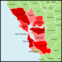
The Bay Area is divided into several sub-regions: The area north of San Francisco Bay is known as North Bay and includes the counties of Marin , Sonoma , Napa and Solano . It is the least urbanized part of the Bay Area and its largest city is Santa Rosa .
West of the San Francisco Bay is the San Francisco Peninsula , locally just the Peninsula ( the peninsula called). This area consists of the city of San Francisco itself and San Mateo County . Most of the cities in this region are arranged in a long chain that stretches along the bay. The Silicon Valley begins in the southern part of the San Mateo County and already includes its administrative seat Redwood City. Silicon Valley continues in South Bay . It consists of Santa Clara County , which includes the cities of Sunnyvale , Santa Clara and San Jose . San Jose forms the end of the Silicon Valley.
The area around the cities of Oakland , Fremont, and Richmond is known as the East Bay . This coincides with the counties Contra Costa and Alameda .
According to the Association of Bay Area Governments , the metropolitan area includes only the nine counties bordering San Francisco Bay and San Pablo Bay. The United States Census Bureau also includes Santa Cruz , which does not border on the Bay of San Francisco, but is economically and culturally connected to it.

climate
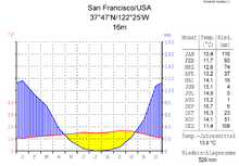
Due to the large expanses of water and the different mountains, the Bay Area includes sub-regions with slightly different climates. The annual average temperatures are between 14 and 16 degrees Celsius. The areas close to the Pacific , with cool summers and mild winters, have significantly lower temperature fluctuations than the inland cities such as Livermore . The latter also have little rainfall , as they are partially separated from the ocean by mountains. In contrast, the coastal areas of North Bay have so much rainfall that coastal redwoods can grow here .

nature
The Bay Area includes several nature-protected local recreation areas , which, however, do not fall into the category of national parks . These include the Point Reyes National Seashore and the Muir Woods National Monument in Marin , as well as the Golden Gate National Recreation Area , which also extends over San Francisco and San Mateo. Mount Diablo State Park is in Contra Costa , and Big Basin Redwoods State Park is in Santa Cruz .
economy
All Bay Area counties have above-average incomes when compared to California. Marin is actually the richest county in the entire United States.
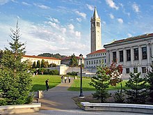
Important for the economy of the Bay Area include the wine region of Napa Valley . The Silicon Valley is the most important American high-tech center . Berkeley has one of the most prestigious universities in the United States.
traffic
Air traffic
The Bay Region has three international airports . The oldest and most important is the San Francisco International Airport (SFO). With around 37 million passengers annually, it is the 13th largest American airport. San Francisco Airport ranks 23rd worldwide in these statistics. It offers several direct flights to Frankfurt as well as direct connections to Düsseldorf and Munich .
The Oakland International Airport (OAK) and the San Jose International Airport (SJC) with 7 and 5 million passengers annually are of increasing importance . Both mainly offer domestic American flights.
Road traffic
The Bay Area is connected to other American metropolitan areas by several highways. The Interstate 5 runs along the West Coast from Seattle to San Diego . The Bay Area is connected to it by other highways. The second important north-south connection is US Route 101 , which runs from Cloverdale via San Francisco along San Jose to Gilroy through the Bay Area.
The most important expressway to the east is Interstate 80 . This begins in San Francisco and runs through Oakland and Sacramento to the American east coast, where it ends in New York .
In addition, other expressways are important for traffic within the Bay Area: Interstate 280 runs parallel to US Route 101 between the San Francisco Peninsula and South Bay. Interstate 580, which connects North Bay with the, begins in San Rafael East Bay connects before it intersects Interstate 80 at Tracy . Interstate 880 connects East Bay and Southbay between Oakland and San Jose.
Several bridges connect the regions of the Bay Area: The Richmond-San Rafael Bridge , the Carquinez Bridge and the Benicia-Martinez Bridge run between the North Bay and the East Bay. The Golden Gate Bridge between the North Bay and the San Francisco Peninsula is the most famous bridge in the Bay Area. The Bay Bridge connects San Francisco with Oakland and, together with the San Mateo – Hayward Bridge and the Dumbarton Bridge, links the San Francisco Peninsula with the East Bay.
Shipping

The fourth largest American seaport is located in Oakland . The worst shipping accident to date in the San Francisco Bay Area occurred on February 22, 1901, when the American liner City of Rio de Janeiro collided with an underwater rock off Fort Point and sank. 138 of the 220 people on board were killed.
Public transport
The main burden of public transport is borne by the S-Bahn-like BART system. In regional traffic, the Caltrain connects the western and the Altamont Corridor Express parts of the south-eastern Bay region. There are also two light rail and tram networks in San Francisco and San José .
In long-distance rail traffic, the region is connected to the Amtrak system ( Coast Starlight , Capitol Corridor , San Joaquin and California Zephyr ) through the Oakland, Emeryville and San José stops . A connection to the California High-Speed Rail lines currently under construction is planned.
Culture
Sports
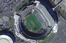
Many professional teams from the most popular sports in the United States have settled in the Bay Area. These include the San Francisco Giants and Oakland Athletics, two teams from Major League Baseball (MLB), as well as two teams from the National Football League (NFL), the San Francisco 49ers and Oakland Raiders .
The Oakland-based Golden State Warriors are members of the National Basketball Association (NBA), the San Jose Sharks of the National Hockey League , and the San Jose Earthquakes of Major League Soccer .
music
The Bay Area was a center of metal music in the 1980s . This is where their particularly fast-played variant, Thrash Metal, developed . Important bands are Exodus from San Francisco, Testament from Oakland and Death Angel from Concord . By far the most successful group is Metallica , which was founded in Los Angeles but only became known after moving to the Bay Area.
The punk rock band Green Day is also from the Bay Area and world famous .
Administrative units
Counties
| county | main place | population | surface |
|---|---|---|---|
| Alameda County | Oakland | 1,443,741 | 1,911 km² |
| Contra Costa County | Martinez | 948.816 | 1,865 km² |
| Marin County | San Rafael | 247.289 | 1,347 km² |
| Napa County | Napa | 124.279 | 1,953 km² |
| San Francisco County | San Francisco | 776.733 | 122 km² |
| San Mateo County | Redwood City | 707.161 | 1,163 km² |
| Santa Clara County | San Jose | 1,682,585 | 3,344 km² |
| Santa Cruz County | Santa Cruz | 255.602 | 1,155 km² |
| Solano County | Fairfield | 394,542 | 2,145 km² |
| Sonoma County | Santa Rosa | 458.614 | 4,082 km² |
| Bay Area (excluding Santa Cruz) | 6,783,760 | 17,932 km² | |
| Bay Area (with Santa Cruz) | 7,039,362 | 19,087 km² |
Cities
| rank | city | population |
|---|---|---|
| 1 | San Jose | 945.942 |
| 2 | San Francisco | 805.235 |
| 3 | Oakland | 390.724 |
| 4th | Fremont | 210.160 |
| 5 | Santa Rosa | 154.212 |
| 6th | Hayward | 140.606 |
| 7th | Sunnyvale | 130,519 |
| 8th | Concord | 122.204 |
| 9 | Vallejo | 116,844 |
| 10 | Santa Clara | 108,518 |
| 11 | Fairfield | 104,897 |
| 12 | Richmond | 102.120 |
| 13 | Berkeley | 101,555 |
| 14th | Daly City | 101.005 |
| 15th | Antioch | 100,586 |
| 16 | Vacaville | 92,691 |
| 17th | San Mateo | 91,601 |
| 18th | Livermore | 79,438 |
| 19th | San Leandro | 78.030 |
| 20th | Napa | 74,966 |
| 21st | Redwood City | 73,691 |
| 22nd | Alameda | 70,699 |
| 23 | Mountain View | 70,090 |
| 24 | Union City | 69,477 |
| 25th | Pleasanton | 66,397 |
| 26th | Milpitas | 64.292 |
| 27 | Walnut Creek | 63,701 |
| 28 | Pittsburg | 63,017 |
| 29 | South San Francisco | 61,354 |
| 30th | Palo Alto | 57,809 |
| 31 | San Rafael | 56.008 |
| 32 | Santa Cruz | 54,778 |
| 33 | Petaluma | 54,660 |
| 34 | Cupertino | 52,948 |
| 35 | Novato | 51,518 |
Web links
literature
- The Bay of San Francisco: the metropolis of the Pacific Coast and its suburban cities: a history . Volume I. by Lewis Publishing Company, Chicago, Ill. Published 1892 Contains index to biographical sketches
- Volume II - Biographies
Individual evidence
- ↑ www.citypopulation.de
- ↑ San Francisco Bay Watershed ( Memento of the original from June 16, 2008 in the Internet Archive ) Info: The archive link was inserted automatically and has not yet been checked. Please check the original and archive link according to the instructions and then remove this notice.
- ^ Association of Bay Area Governments
- ↑ United States Census Bureau ( Memento of the original from August 1, 2008 in the Internet Archive ) Info: The archive link was inserted automatically and has not yet been checked. Please check the original and archive link according to the instructions and then remove this notice. : According to this definition, even the far south of San Benito County would be included in the Bay Area.
- ↑ The Center for Measuring University Performance ( Memento of the original from July 10, 2007 in the Internet Archive ) Info: The archive link was inserted automatically and has not yet been checked. Please check the original and archive link according to the instructions and then remove this notice. (PDF; 1.3 MB) at Arizona State University
- ↑ Federal Aviation Administration ( Memento of the original from January 14, 2009 in the Internet Archive ) Info: The archive link was automatically inserted and not yet checked. Please check the original and archive link according to the instructions and then remove this notice.
- ↑ www.airports.org
- ↑ World Port Ranking 2006 ( Memento of the original from December 21, 2008 in the Internet Archive ) Info: The archive link was inserted automatically and has not yet been checked. Please check the original and archive link according to the instructions and then remove this notice.


