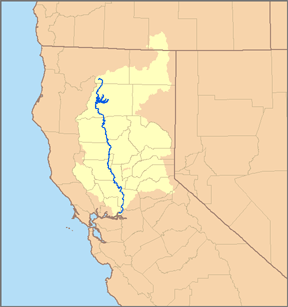
Sacramento River
| Sacramento River | ||
|
Sacramento River basin |
||
| Data | ||
| Water code | US : 1654949 | |
| location | California , USA | |
| River system | Sacramento River | |
| discharge |
Lake Siskiyou 41 ° 16'24 " N , 122 ° 24'5" W. |
|
| muzzle |
Sacramento-San Joaquin River Delta Coordinates: 38 ° 3 '48 " N , 121 ° 51' 10" W 38 ° 3 '48 " N , 121 ° 51' 10" W.
|
|
| length | 607 km | |
| Catchment area | 69,930 km² | |
| Left tributaries | McCloud River , Pit River , Feather River , American River | |
| Reservoirs flowed through | Shasta dam | |
| Big cities | Redding, Sacramento | |
| Navigable | 300 km to Red Bluff | |
|
Estuary of the Sacramento River |
||
At 607 kilometers, the Sacramento is the longest river in the US state of California .
The river rises southwest of Mount Shasta in the southern part of the cascade chain and flows through the plains of the Sacramento Valley before it finally joins the San Joaquin River around 50 kilometers south of Sacramento in Suisun Bay and over the Carquinez Strait into the bays flows from San Pablo and San Francisco . The major tributaries of Sacramento are the Feather River , McCloud River, and Pit River , the latter of which is the longest at 333 kilometers in length.
The Sacramento is navigable upstream for nearly 300 kilometers to Red Bluff ; for ocean-going vessels, the limit is the city of Sacramento. Marine animals such as gray whales and sea lions sometimes get lost far inland behind the navigable part of the river in search of food and later cannot find their way back to the Pacific .
At Shasta Lake , the Sacramento is dammed in the Shasta Dam .
Cities on the river
- Redding
- Red bluff
- Chico (nearby)
- Sacramento
- Rio Vista
Web links
- SacramentoRiver.org
- Sacramento River Watershed Program
- Sacramento River Preservation Trust
- Upper Sacramento River Exchange


