Sacramento Valley
| Sacramento Valley | |
|---|---|
|
Typical landscape in the Sacramento Valley |
|
| location | California (USA) |
| Waters | Sacramento River |
| Geographical location | 39 ° 0 ′ 0 ″ N , 121 ° 30 ′ 0 ″ W |

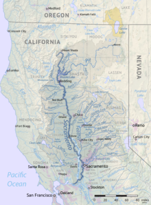
The Sacramento Valley is the northern part of California's long valley . In its center is the city of Sacramento , the capital of the state of California and the economic center of the region. It comprises a total of ten counties .
geography
The Sacramento River , which runs through the valley and flows further to the west into the Pacific , is largely responsible for the character of the Sacramento Valley . The valley is bounded and shaped by various mountain ranges (the Northern Coast Ranges in the west, the southern Siskiyou Mountains in the north, and the northern Sierra Nevada in the east). Many agricultural areas are located in non- urbanized areas . This is how fruit, vegetables and wine are grown. Extensive irrigation of the region is guaranteed by the river system of the Sacramento River. The flat subsoil and the soil in this area enable widespread agriculture and livestock farming in the region. Citrus fruits, nuts, almonds and walnuts are of great importance in the valley and are also exported in substantial quantities throughout the United States and other overseas countries. The proceeds from these products are an important part of the Californian economy. The city of Corning also processes olives grown in the region in large quantities for oil production and consumption. The Sunsweet Growers Incorporated , which specializes in the production and processing of fruits, is located with its headquarters in Yuba City also in the Sacramento Valley. The valley accounts for more than two-thirds of the global plum market through the more than 400 producers in the Sacramento Valley.
The area of the Sacramento Valley consists of fields and arable land of flat meadows and inhabited areas, on the edge of the cities also of so-called suburbs (American suburbs). Due to its location on the river, the Sacramento Valley had larger areas of forest before the arrival of European settlers in the 19th century. Most of it was cleared during the California gold rush and subsequent wave of immigration. However, there are still larger forested areas in the region, mostly pine and pine forests.
A distinctive feature of the Sacramento Valley is the Sutter Buttes , a small circular complex of eroded lava hills that rise above the plains of California's Sacramento Valley, about 44 miles north of Sacramento. They are considered to be the smallest mountain range in the world.
climate
The climate in the Sacramento Valley is characterized by its location a few kilometers inland, but also by the flat landscape. Like almost the entire state of California, the Sacramento Valley is also part of the subtropical climate zone. In summer there is usually hardly any precipitation , the average daytime temperatures are usually over 30 degrees in the shade. Occasionally a coastal breeze coming from the San Francisco Bay area brings slightly cooler temperatures and higher humidity to the valley. If the wind continues, it is gusty with wind speeds that can reach more than 50 km / h. Winds from the Pacific coast bring precipitation, which occurs more frequently in winter, when daytime temperatures can drop to less than 15 degrees. In Sacramento, there is an average of ten years of snowfall during the winter months.
Major cities in the Sacramento Valley
Web links
Individual evidence
- ↑ Sunsweet Growers Inc. ( Memento of the original from September 30, 2011 in the Internet Archive ) Info: The archive link was automatically inserted and not yet checked. Please check the original and archive link according to the instructions and then remove this notice.
- ↑ Stienstra, Tom: State buys parcel in Sutter Buttes But public access to Peace Valley could take years , in: San Francisco Chronicle of March 18, 2004, last accessed on December 2, 2019
- ↑ Information on the California climate


