
Sutter Buttes
| Sutter Buttes | ||
|---|---|---|
 The Sutter Buttes over Sutter, California |
||
| Highest peak | South Butte ( 628 m ) | |
| location | Sutter County , California | |
| Is lying in | Central Valley | |
|
||
| Coordinates | 39 ° 12 ′ N , 121 ° 49 ′ W | |
| Type | Volcanic cone | |
| Age of the rock | at least 1.5 million years | |

The Sutter Buttes ( Butte is the English name for "pointed tip"), also known by the Maidu Indians as Histum Yani ( The Middle Mountain ), are a small circular complex of eroded lava hills that rise above the plains of California's Central Valley to raise.
The highest point, South Butte, rises approximately 628 feet above sea level. The Buttes are in the northern part of the Central Valley, just outside of Yuba City . They are named after Johann August Sutter , a pioneer of Swiss descent who received large estates from the Republic of Mexico in 1841 and thus founded the colony of New Helvetia . The Sutter Buttes are considered the smallest mountain range in the world.
Geography and geology
The mountain group is about 16 kilometers in diameter and is circular. It was formed about 1.5 million years ago when a volcano erupted, which is now extinct . Its origin and its relation to other volcanic activities in the region is the subject of current research. Charles A. Wood suspects a connection with the volcanoes in the Cascade Mountains further north, but the Sutter Buttes differ significantly in terms of age and shape.
Meaning in the traditions of the Indians
The Sutter Buttes play a prominent role in the creation stories of the Maidu and Wintun Indian tribes . The Maidu lived east of the mountains, the Wintun west. None of the tribes claimed the mountains for themselves, there were only seasonal camps that were used for foraging and hunting. In the stories of these tribes, the first woman and man were created here and it is the place to which the souls of the deceased return. Colusa , which is very close, was an important center of the Kuksu religion, which was practiced in much of northern California.
Younger history and access

Public access to the Sutter Buttes is restricted as much of the land is owned by ranchers and sheep farmers . However, several local organizations, including the Middle Mountain Foundation and the Sutter Buttes Society, organize tours in the mountains. Since 1929, the state of California had planned to put the land under protection and make it accessible to the general public, but it wasn't until 2003 that it actually managed to acquire an area of 7.2 square kilometers.
In 1963, rocket silos for Titan I rockets were built on the edge of the Buttes . Although the silos were only active from 1963 to 1965 and were largely dismantled afterwards, the launch site still attracts many passers-by and vandals. The silo is on private land and is not accessible.
Picture gallery

The Sutter Buttes on an overcast day
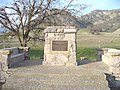
A monument was erected in honor of John C. Frémont , who stayed here.
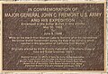
inscription


Individual evidence
- ^ Tom Stienstra: State buys parcel in Sutter Buttes But public access to Peace Valley could take years . In: San Francisco Chronicle , Hearst Corporation , March 18, 2004, p. B-1. Retrieved May 29, 2009.
- ^ Charles A. Wood, Jürgen Kienle, eds .: Volcanoes of North America . Cambridge University Press , 1990, ISBN 0-521-43811-X , pp. 225-226.
- ^ Middle Mountain Foundation
- ^ Sutter Buttes Society
- ↑ Titan 1 . California Cold War Museum & Memorial. Retrieved December 12, 2008.
Web links
- Stuart Allan: California Road and Recreation Atlas . Benchmark Maps, 2005, ISBN 0-929591-80-1 , p. 64.
- Middle Mountain Foundation - A Sutter Buttes Regional Land Trust Yuba Historical Society [1]
- Sutter Buttes in the United States Geological Survey's Geographic Names Information System
- South Butte, California . Peakbagger.com. November 1, 2004, 2004. Retrieved November 28, 2007.