Sacramento
| Sacramento | |
|---|---|
| Nickname : Sac, Sac-Town, Old Sac, The Big Tomato | |
 Aerial view of downtown Sacramento |
|
 flag |
|
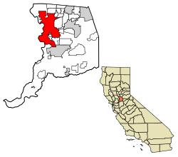
| Located in Sacramento County and California | |
| Basic data | |
| Foundation : | 1849 |
| State : | United States |
| State : | California |
| County : | Sacramento County |
| Coordinates : | 38 ° 35 ′ N , 121 ° 29 ′ W |
| Time zone : | Pacific ( UTC − 8 / −7 ) |
|
Inhabitants : - Metropolitan Area : |
508,529 (as of 2018) 2,103,956 |
| Population density : | 2,021.2 inhabitants per km 2 |
| Area : | 257 km 2 (approx. 99 mi 2 ) of which 251.6 km 2 (approx. 97 mi 2 ) are land |
| Height : | 8 m |
| Postcodes : | 942xx, 958xx |
| Area code : | +1 916 |
| FIPS : | 06-64000 |
| GNIS ID : | 1659564 |
| Website : | www.cityofsacramento.org |
| Mayor : | Darrell Steinberg (D) |
Sacramento [ ˌsækɹəˈmɛntoʊ ] is the capital of the US state California . The city is located in the center of the Sacramento Valley , at the confluence of the American River and the Sacramento River, and has a population of 508,529 (2018 estimate, US Census Bureau).
history
From 1839 the area was part of New Helvetia , a private colony that the Swiss immigrant Johann August Sutter founded with the permission of the Mexican administration. At the confluence of the American River in the Sacramento River, he laid Fort Sutter , from which the city emerged. After the Mexican-American War of 1846/48, all of California became American. In 1848, Sutter's colony collapsed under the pressure of the California gold rush . As a result of the gold rush, the settlement of Sacramento emerged as a gold rush settlement at the confluence of the American River in the Sacramento River. During this time the prospectors came here by ship and then searched on foot.
Sacramento was declared a city in 1850 and the capital of the state of California in 1854. After the first railroad opened in 1856, Sacramento grew into a commercial hub and quickly became known as the Boomtown on the River . The highly visible State Capitol was built between 1861 and 1869, and the construction of a canal in 1963 made shipping much easier. In 1964 the suburb of North Sacramento was incorporated. Sacramento is known for the textile and food industries .

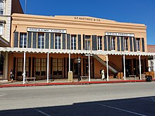
Five locations in Sacramento have National Historic Landmark status , including the Pony Express Terminal and the Old Town . 65 buildings and sites in the city are listed on the National Register of Historic Places (NRHP) (as of October 31, 2018).
climate
Although the city is only 120 kilometers from the coast of the Pacific , it is often very hot in midsummer. The low humidity and the wind that brings cool air in from the San Francisco Bay at night make the stay bearable. The Sacramento area has a Mediterranean climate with mild, mostly humid winters and warm, dry summers.
| Sacramento, California | ||||||||||||||||||||||||||||||||||||||||||||||||
|---|---|---|---|---|---|---|---|---|---|---|---|---|---|---|---|---|---|---|---|---|---|---|---|---|---|---|---|---|---|---|---|---|---|---|---|---|---|---|---|---|---|---|---|---|---|---|---|---|
| Climate diagram | ||||||||||||||||||||||||||||||||||||||||||||||||
| ||||||||||||||||||||||||||||||||||||||||||||||||
|
Monthly average temperatures and rainfall for Sacramento, California
|
|||||||||||||||||||||||||||||||||||||||||||||||||||||||||||||||||||||||||||||||||||||||||||||||||||||||||||||||||||||||||||||||||||||||||||||||||||||||||||||||||||||
Natural events
Due to its geographical location near the San Andreas Fault , where two tectonic plates collide, Sacramento is repeatedly affected by earthquakes.
Population development
| year | Residents¹ |
|---|---|
| 1950 | 137,572 |
| 1960 | 191,667 |
| 1970 | 257.105 |
| 1980 | 275,741 |
| 1990 | 369.365 |
| 2000 | 406606 |
| 2010 | 466.488 |
| 2018 | 508,529 |
¹ 1950–2010: census results; 2018: US Census Bureau estimate
Demographics
According to the 2010 census, the population was 34.5 percent white and 14.6 percent African-American; 18.3 percent were of Asian origin. 26.9 percent of the population were Hispanics . The median income per household was 2,015 at 50,739 US dollars . 22.0 percent of the population lived below the poverty line.
Culture and sights
Sacramento has been home to the California State Library since 1947 . The Fort Sutter Pioneer Museum and the California Railroad Museum , one of the best railroad museums in the United States, are well worth a visit . The museum is located in the so-called "Old Town", a reconstructed part of the city from the 19th century. Other attractions include the California State Fair Grounds (Cal Expo) on the American River, the Sleep Train Arena (former home ground of the NBA team Sacramento Kings ) just outside of Interstate 5 near the airport and Sacramento's Zoo near downtown.
With a strong music scene and bands associated with the city such as the Deftones , Papa Roach and Far , Sacramento is also considered the cradle of Nu Metal . In 1972 the city was immortalized in a song by Middle Of The Road .
Economy and Infrastructure
The metropolitan area of Sacramento generated an economic output of 112.2 billion US dollars in 2016.
Fruit growing, canning, machine , automobile, wood and food industries are of economic importance .
traffic
Sacramento has access to Interstate 80 and Interstate 5 and is located approximately 140 km northeast of San Francisco , 200 km southwest of Reno , and 550 km north of Los Angeles . Flights to many cities in the United States are available from Sacramento International Airport . The light rail tram is an important pillar of urban transport .
The Port of Sacramento is connected to the Sacramento River by a deep-water channel, creating a navigable connection to the Bay of San Francisco .
Sacramento has two airports, Sacramento Airport in the northwest of the city and Sacramento Mather Airport , a former air force base, on the southeastern outskirts.
education
California State University, Sacramento is located in Sacramento .
sports clubs
- Sacramento Gold Miners ( Canadian Football League )
- Sacramento Kings ( NBA )
- Sacramento Rivercats ( MILB )
- Sacramento Knights ( NPSL )
- Sacramento Mountain Lions ( UFL )
- Sacramento Republic ( USL )
Town twinning
- Chișinău , Moldova
- Hamilton , New Zealand
- Jinan , People's Republic of China
- Liestal , Switzerland
- Manila , Philippines
- Matsuyama , Japan
- Yongsan-gu (district in central Seoul ), South Korea
- Bethlehem ( Palestinian Territories ), since 2009
People born in Sacramento
Others
- Sacramento is one of the exemplary selected US cities in Ken Burns ' documentary series The War about World War II .
- The bands Deftones , Groovie Ghoulies , Hoods , Oleander , Tesla , Cake , Middle Class Rut and Dance Gavin Dance were founded in Sacramento.
literature
- Christopher J. Castaneda, Lee MA Simpson: River City and Valley Life: An Environmental History of the Sacramento Region. University of Pittsburgh Press, Pittsburgh 2013, ISBN 978-0-8229-7918-0 .
Web links
- further information and pictures on CityData.com (English)
Individual evidence
- ↑ Sacramento's canning industry canned every imaginable farm product, but tomatoes were the best-known, earning Sacramento the nickname "The Big Tomato." The Big Tomato - Midtown, Sacramento Monthly
- ↑ Leland, Kupcha: The big tomato - Sacramento : a guide to California's capital city, in 1984
- ↑ List of NHL by State . National Park Service , accessed October 31, 2018.
- ↑ Search mask database in the National Register Information System. National Park Service , accessed October 31, 2018.
- ↑ US Census Bureau QuickFacts selected: Sacramento city, California. Retrieved October 12, 2019 .
- ^ US Department of Commerce, BEA, Bureau of Economic Analysis: Bureau of Economic Analysis. Retrieved July 4, 2018 (American English).


