
Mount Shasta
| Mount Shasta | ||
|---|---|---|
.jpg) Mount Shasta, view from the northwest |
||
| height | 4322 m | |
| location | Siskiyou County , California , United States | |
| Mountains | Cascade chain | |
| Dominance | 538 km → White Mountain Peak | |
| Notch height | 2977 m ↓ Scarface Pass | |
| Coordinates | 41 ° 24 '33 " N , 122 ° 11' 42" W | |
|
||
| Type | Stratovolcano | |
| rock | Basaltandesite , andesite , dacite | |
| Age of the rock | Middle Pleistocene to Holocene | |
| Last eruption | 1786 | |
| First ascent | 1854 by Elias D. Pierce | |

The Mount Shasta is a stratovolcano in the north of the State of California . The town of the same name, Mount Shasta, with around 3000 inhabitants, is located at the foot of the mountain at an altitude of 1100 meters.
With a height of 4322 m , a volume of approx. 350 km³ and a diameter of approx. 27 km, it is the largest volcano in the cascade range . Within the Cascade Range, only Lassen Peak lies further south. After Mount Rainier , it is the second highest mountain in its mountain range, the second highest volcano in the USA, one of the highest mountains in California and, after Harris, the highest landform in the USA outside of Alaska . The difference in altitude between its base and the summit is one of the largest in the world at around 3350 m. No other volcano in the Cascade Range has uncovered as much eruption material as Mount Shasta. It is still volcanically active today.
Since 1976 the mountain has had the status of a National Natural Landmark . It lies within the Shasta-Trinity National Forest .
Geology, geomorphology and eruption history
General
The volcanic body of Mount Shasta rests on bedrock, the surface of which is approx. 1100 to 1400 m. These are mainly mudstone , slate and limestone layers, which are Devonian to Jurassic ages, as well as quartzite .
The extraordinary size of Mount Shasta can be explained by the fact that the mountain is a volcanic complex composed of four individual cones. These overlapping individual components can still be traced today. Each of these cones shows the characteristics of a stratovolcano . The lion's share of the volcanic body consists of silicate andesite to dacite with a proportion of about 58-64% SiO 2 . The composition of the rock indicates that the magma was erupted from relatively deep chambers . The presence of dacite indicates that some of the magma resided in higher areas for at least a while. Consistent with the fact that Mount Shasta produces intermediate rock are the blocky lava flows that can be found around the mountain.
The oldest volcanic rocks that can be traced back to the center of activity of today's volcano are 593,000 years old. Until about 300,000 to 380,000 years ago, a volcanic body had formed that was roughly the same size as Mount Shasta today. At that time, the entire northwest flank of the mountain collapsed, an event that is likely to mark the largest gravitational mass movement in the geomorphological history of what is now the United States. The volume moved was estimated at 45 km³, which corresponds to ten times what was moved when the northern flank of Mount St. Helens slipped in 1980 . The material was spread over an area of 675 km² and the resulting sediment body extends up to 49 km from the summit of Mount Shasta. Even today, hundreds of small hills and ridges are indicators of this enormous event. The resulting hollow form in the mountain was then completely filled with newer eruption material. Only a small remnant of the original volcanic body can be found on the west side of the mountain.
Primary cone
.jpg)
At Mount Shasta, four primary eruption channels can be differentiated, each associated with a volcanic cone: Sargents Ridge, Misery Hill, Shastina and Hotlum.
- Sargent's Ridge is the oldest cone, around 250,000 years old, and its products are mainly visible today on the south side of the volcanic body.
- Misery Hill was formed around 130,000 years ago. It now forms a large part of the upper part of the mountain and rests on the former northern flank of Sargents Ridge.
- Shastina's age is approximately 9,700 to 9,400 years. Its creation may overlap with that of Hotlum, although Shastina seems a little older. The cone is easily recognizable in today's landscape as a characteristic secondary cone in the west of the summit structure (see title photo on the right) and reaches a height of approx. 3,790 m. It consists mainly of pyroxene-rich andesite. Its slopes are quite steep and covered in debris from multiple lava dome collapses. Repeated pyroclastic currents have eroded a ravine ("Diller's Canyon") on its western flank. On the lower slope areas, multiple high-volume lava flows of a blocky nature emerged. If Shastina were a mountain in its own right, it would be the fourth highest peak in the Cascade Range (behind Mount Rainier, Mount Rainier's Liberty Cap and Mount Shasta itself).
- Hotlum ("steep rock" in the language of the Wintun Indians) forms the current summit area as well as the north and north-west slopes of the mountain, which are characterized by powerful andesitic lava flows. The summit itself is an eroded, silicate lava dome. Hotlum is the only cone that has been active for the past 3,500 years. The main crater has a diameter of approx. 800 m and is filled by five overlapping lava domes, the forming material of which has a high proportion of pyroxene and hornblende. There are small fumaroles near the summit . The escaping gases have a temperature of approx. 84 ° C. The general activity of the fumaroles appears to be decreasing. There is also an acidic hot spring close to the summit. The temperature of the exiting water varies between 72 and 85 ° C.
Each of the four primary cones were formed in a similar manner. It is noticeable that their development time was relatively short (a few hundred or thousand years). The main processes were the formation of Dacite lava domes, cinder cones and pyroclastic flows. Lava flows occurred mainly on the sides of the cinder cones.
Only two of the cones were shaped over by glacial erosion in the Pleistocene (see below).
Secondary cone
In addition to the main cones listed above, there are subordinate domes and cones on Shasta's slopes and the surrounding area. Many of these lie along two columns running north-south and east-west, a fact which howel led Howel to attribute the emergence of the activity centers to them. The most striking of these secondary landforms is Black Butte, an almost perfectly symmetrical lava dome west of Mount Shasta. It rises approx. 760 m above its immediate surroundings and reaches an absolute height of approx. 1930 m. It was created in the Holocene. Other domes and cinder cones on Shasta's flanks include. a. Bear, Black and Red Butte. A particularly large number of nameless cinder cones and domes lie along the north-south axis of the mountain.
Prominent lava flows
Several lava flows are associated with the formation of Shasta's cones. Many of them were not erupted directly at the cone tips, but below them. The most important of these are:
- Lava Park flow: It originated nine kilometers from today's summit and moved down the northwestern slope. It is up to 110 m thick and around 9,500 years old. It has a very rough surface.
- Military Pass flow: This lava flow is on the northeast side of the mountain. It is nine kilometers long and 145 meters thick at the front. This makes it the most powerful lava flow on Mount Shasta. It originated at the summit cone and is the youngest lava flow on the mountain.
Significant tephra layers
During the Holocene, Mount Shasta rarely produced significant amounts of tephra . According to Hoblitt et al. And Miller, only two noteworthy low volume sites have been identified. All authors mention an eruption 9,700 years ago, which produced the tephra layer "Red Banks" known today among alpinists. This is a popular marker for the Holocene among geomorphologists and consists of heavily oxidized, partially caked dacite and Dacite-andesitic pumice. The eruption responsible for this had a volume of approximately 0.1 km³ and its deposits cover an area of 350 km².
Pyroclastic currents
Deposits of pyroclastic currents can now be found on each side of the mountain. Black Butte, Shastina and Hotlum have been particularly productive in this regard. Repeated currents have formed Diller Canyon at Shastina Cone, reaching a distance of up to 18 km from the crater. A small overview of past events can be found in Miller.
Holocene activity and current surveillance
Mount Shasta has erupted at least 13 times in the past 10,000 years, eight times in the past 4,500 years and three times in the past 750 years. Only Mount St. Helens erupted more frequently than Mount Shasta in the Holocene. These eruptions did not occur at regular intervals, but accumulated in periods of activity separated by quiet periods (up to 2,000 years). The last eruption probably took place in 1786. This may have been observed by Jean-François de La Pérouse . A radiocarbon dating confirmed a date the last eruption about 200 years ago. A slight steam eruption may have occurred in 1855. The presence of fumaroles at the summit (see above) could be an indicator of magma still under the mountain.
The activity of Mount Shasta is monitored by means of seismographs .
Recent and Pleistocene glaciation
The summit region is home to five glaciers . In addition to the Hotlum, Wintun and Mud Creek Glaciers, there is also the largest in California, the Whitney Glacier. None of them reach below about 2,900 m. They are not remnants of the Pleistocene glaciation, but their formation is to be placed in the Holocene .
The volcano was heavily glaciated during the Pleistocene: cirques on the south and south-east sides and moraines in the foothills are evidence of this. The cone (see above) Sargents ridge was severely eroded during the Illinois and Wisconsin glaciation, Misery Hill only during the Wisconsin. Since the eruption centers Shastina and Hotlum come from the Holocene, the corresponding cones have been able to retain their shape more or less until today.
Hydrology
Since Mount Shasta is relatively isolated as a mountain, it is the center of an almost radial river system. Three regionally important river systems drain the flanks of the volcanic complex: the Shasta River in the northwest, the Sacramento River in the (south) west and the McCloud River in the east. In many places the lower areas of the mountain are formed by material deposited by mudslides and pyroclastic currents. These deposits have a slope of only approx. 5 ° and are formed by particles of very large grain sizes , which is why many streams that arise further up the mountain seep into the lower areas.
Alpinism
Ascent history
The first ascent was made on August 14, 1854 by Elias D. Pierce. The first women to reach the summit were Mary A. White, Harriet Catherine Eddy, Mary (Campbell) McCloud, Ann A. Lowery, and Susan (Hodgeboom) Gage. In 1998, Robert Webb managed to climb the summit six times within 24 hours. He conquered a total of 11,500 meters in altitude, which was a world record.
On average, two people die on the mountain each year and only half of the 12,000 people who attempt an ascent reach the summit.
Today's normal routes
Today there are numerous documented and partly well-trodden paths on Mount Shasta. It usually takes two days to climb and descend:
Southwest side
- Avalanche Gulch: The most popular route to the summit runs through the hollow form called Avalanche Gulch on the southwest side of the mountain. It begins at the Bunny Flat hikers' car park (approx. 2,120 m). The hut of the Sierra Club ("Horse Camp") and the attached campground at about 2410 m are quickly reached. Then you reach Helen Lake (3180 m) via steep switchbacks, where camping is usually done as part of the typical two-day tour. The most demanding part of the path is the steep section above the lake, at the end of which the so-called Red Banks (3960 m) have to be overcome. Due to the steepness and the snow that is often present, this represents the technical key point on the Avalanche Gulch Route. After the Red Banks, you go to the Misery Hill cone on flatter terrain.
- Casaval Ridge: The path over the Casaval Ridge is steeper, more technical and more exposed than the Avalanche Gulch Route and branches off near Horse Camp. It is best done when there is a lot of snow. Overnight stays at the upper end of Giddy Giddy Gulch (2990 m). The route reaches the summit structure north of the Red Banks.
- Cascade Gulch: This route is ideal if you want to reach both Shastina and the main summit. The route runs through the moat between these two cones.
- Green Butte Ridge: This route follows the ridge that borders the Avalanche Gulch to the east. Due to the relative avalanche safety in the lower part, it is very popular in winter but very exposed to wind. The ridge joins Sargents Ridge at approx. 3660 m.
- Sargents Ridge: This trail in the lower part over the ridge east of Green Butte Ridge. It does not require great technical ability, but is exposed. It is best done in the first half of the climbing season.
- West Face: The way over the west flank is just as easy as the standard route through the Avalanche Gulch, but a little longer. From the Sierra Club Hut you cross to the north. There are good opportunities for a bivouac at around 2800 m . The route then runs straight through the conspicuous run in the western flank. The route is particularly recommended at the beginning of the climbing season when there is still enough snow.
East Side
- Clear Creek: From a technical point of view, this route is the easiest on Mount Shasta, but it is comparatively long. Fresh water and camping facilities are located at approx. 2620 m
- Hotlum / Wintun Snowfield: This trail runs over the year-round snowfield between the Hotlum and Wintun glaciers. The start is at the Brewer Creek hiking car park. Above the tree line it quickly gets steep. Bivouacs can be found at approx. 3000 m. The key point is at the so-called “Ship Rock” at 4020 m.
- Wintun Glacier: The route runs over the Wintun Glacier and is reserved for experienced glacier walkers.
North side
- Bolam / Whitney Ridge: A relatively infrequent route that does not often offer good conditions. From the lower end of Bolam Glacier, traverse a ramp to the left of Whitney Glacier.
- Bolam Glacier: An easy glacier tour. You start from the Northgate Walker Parking Lot. after half a day you can reach the glacier. You can also camp here.
- Hotlum / Bolam Ridge: Comparatively demanding tour. You start at the Northgate hiking car park. You can camp at the tree line or at about 3050 m, where there is also water. Above you follow the lateral moraine to a ramp on which you can easily reach 3990 m. Steep terrain then leads over the Bolam Gulley and along the ridge to the north summit. From here you follow the ridge to the main summit.
- Hotlum Glacier: Comparatively rarely climbed and reserved for experienced alpinists. Start at Brewer Creek Hikers Parking Lot. You can bivouack at the foot of the glacier. Since the Hotlum Glacier is crossed, it is a real high-altitude tour while the crevasses have to be overcome. The higher you get, the more difficult it is to find a route. Best done in autumn.
- Whitney Glacier: This tour also starts from the Northgate Hiker Parking Lot. Whitney Glacier can be reached via Bolam Glacier. Finding a route is difficult in the lower part of the glacier, further up there is a risk of falling rocks.
There is currently no quota regulation regarding the number of ascents. Nevertheless, mountaineers must obtain a climbing permit and a so-called wilderness permit. You can either get these at the ranger stations in Mount Shasta or McCloud or you can issue them yourself at the hiker parking lots.
Religious meaning
Various religious groups see the mountain as a spiritually significant place. For the Indians resident in the area, the mountain was a sacred place long ago. Since the late 20th century, the mountain also is New Age vehicle trailers, UFO and Bigfoot - and reptilians -Gläubigen considered special locality. According to another myth, the interior of the mountain is home to survivors of the fall of Lemuria .
Image gallery

Mount Shasta
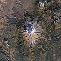
Inclusion of Landsat 8 (2014)


Web links
- Mount Shasta in the Global Volcanism Program of the Smithsonian Institution (English)
- Geological processes
- MountShasta.com
- Mount Shasta on summitpost.org (English)
Individual evidence
- ^ A b Wood and Kienle: Volcanoes of North America. United States and Canada. Cambridge: Cambridge University Press, 1990, pp. 214-216
- ↑ a b Howel: Mount Shasta, A Cascade Volcano. In: Repr. Fr. Jour. of Geology July - August 1932, p. 420
- ↑ a b c d Harris: Fire mountains of the west. The Cascade and Mono Lake volcanoes. Missoula, MT: Mountain Press Publishing Company, 2005, p. 99
- ↑ Zanger: Mt. Shasta. History, Legend & Lore. Berkeley, California: Celestial Arts, 1992, p. 9
- ↑ a b Crowley, et al .: Analysis of potential debris flow source areas on Mount Shasta, California, by using airborne and satellite remote sensing data. In: Remote Sensing of Environment 87. Issues 2-3, 2003, p. 346
- ↑ US National Park Service: Mount Shasta. National Natural Landmark, 2004. < https://www.nps.gov/subjects/nnlandmarks/site.htm?Site=MOSH-CA > (accessed on 2020-02-17)
- ↑ Howel: Mount Shasta, A Cascade Volcano. In: Repr. Fr. Jour. of Geology July - August 1932, p. 418
- ^ Miller: Potential Hazards from Future Eruptions in the Vicinity of Mount Shasta Volcano, Northern California. Washington: United States Government Printing Office, 1980, p. 7
- ^ Harris: Fire mountains of the west. The Cascade and Mono Lake volcanoes. Missoula, MT: Mountain Press Publishing Company, 2005, pp. 102-103
- ↑ Brantley and Glicken: Volcanic Debris Avalanches: Earthquakes & Volcanoes. v. 18, n.6, 1986, p. 197ff.
- ^ Crandell: Gigantic Debris Avalanche of Pleistocene Age from Ancestral Mount Shasta Volcano, California and Debris-Avalance Hazard Zonation. In: USGS Bulletin 1861, 1989.
- ^ Harris: Fire mountains of the west. The Cascade and Mono Lake volcanoes. Missoula, MT: Mountain Press Publishing Company, 2005, p. 103
- ^ A b c Wood and Kienle: Volcanoes of North America. United States and Canada. Cambridge: Cambridge University Press, 1990, p. 215.
- ↑ Howel: Mount Shasta, A Cascade Volcano. In: Repr. Fr. Jour. of Geology July - August, 1932, p. 427
- ^ Harris: Fire mountains of the west. The Cascade and Mono Lake volcanoes. Missoula, MT: Mountain Press Publishing Company, 2005, pp. 104f.
- ↑ Howel: Mount Shasta, A Cascade Volcano. In: Repr. Fr. Jour. of Geology July - August 1932, p. 428
- ^ Selters, A. & Zanger, M .: The Mount Shasta Book (3rd ed.). Wilderness Press. ISBN 978-0-89997-404-0 . 2006
- ↑ Zanger: Mt. Shasta. History, Legend & Lore. Berkeley, California: Celestial Arts, 1992, p. 46
- ^ Harris: Fire mountains of the west. The Cascade and Mono Lake volcanoes. Missoula, MT: Mountain Press Publishing Company, 2005, p. 106
- ↑ Crandell and Nichols: Volcanic hazards at Mount Shasta, California. US Geological Survey, Department of the Interior, 1987, p. 13
- ^ Miller: Potential Hazards from Future Eruptions in the Vicinity of Mount Shasta Volcano, Northern California. Washington: United States Government Printing Office, 1980, pp. 27f.
- ^ Harris: Fire mountains of the west. The Cascade and Mono Lake volcanoes. Missoula, MT: Mountain Press Publishing Company, 2005, p. 107
- ↑ Howel: Mount Shasta, A Cascade Volcano. In: Repr. Fr. Jour. of Geology July - August, 1932, pp. 428f.
- ^ A b c d Miller: Potential Hazards from Future Eruptions in the Vicinity of Mount Shasta Volcano, Northern California. Washington: United States Government Printing Office, 1980, p. 3
- ↑ Howel: Mount Shasta, A Cascade Volcano. In: Repr. Fr. Jour. of Geology July - August 1932
- ↑ Howel: Mount Shasta, A Cascade Volcano. In: Repr. Fr. Jour. of Geology July - August 1932, p. 421 u. 428
- ↑ Howel: Mount Shasta, A Cascade Volcano. In: Repr. Fr. Jour. of Geology July - August 1932, p. 422ff.
- ^ Miller: Potential Hazards from Future Eruptions in the Vicinity of Mount Shasta Volcano, Northern California. Washington: United States Government Printing Office, 1980, pp. 9 and 29
- ^ A b Harris: Fire mountains of the west. The Cascade and Mono Lake volcanoes. Missoula, MT: Mountain Press Publishing Company, 2005, p. 100
- ^ Miller: Potential Hazards from Future Eruptions in the Vicinity of Mount Shasta Volcano, Northern California. Washington: United States Government Printing Office, 1980, p. 9
- ↑ Hoblitt, et al .: eruptive histories and Volcanic Hazards Assessments at Select Cascade Range Volcanoes. Excerpts from: Hoblitt, et al. (1987): Volcanic Hazards with Regard to Siting Nuclear-Power Plants in the Pacific Northwest: US Geological Survey Open-File Report 87-297, 1987.
- ^ Miller: Potential Hazards from Future Eruptions in the Vicinity of Mount Shasta Volcano, Northern California. Washington: United States Government Printing Office, 1980, p. 20
- ^ Wood and Kienle: Volcanoes of North America. United States and Canada. Cambridge: Cambridge University Press, 1990, p. 216
- ↑ Howel: Mount Shasta, A Cascade Volcano. In: Repr. Fr. Jour. of Geology July - August 1932, p. 11
- ↑ Hoblitt, et al .: eruptive histories and Volcanic Hazards Assessments at Select Cascade Range Volcanoes. Excerpts from: Hoblitt, et al. (1987): Volcanic Hazards with Regard to Siting Nuclear-Power Plants in the Pacific Northwest: US Geological Survey Open-File Report 87-297, 1987.
- ^ A b Miller: Potential Hazards from Future Eruptions in the Vicinity of Mount Shasta Volcano, Northern California. Washington: United States Government Printing Office, 1980, p. 35
- ^ Miller: Potential Hazards from Future Eruptions in the Vicinity of Mount Shasta Volcano, Northern California. Washington: United States Government Printing Office, 1980, p. 17
- ^ A b c Miller: Potential Hazards from Future Eruptions in the Vicinity of Mount Shasta Volcano, Northern California. Washington: United States Government Printing Office, 1980, p. 41
- ↑ Crandell and Nichols: Volcanic hazards at Mount Shasta, California. US Geological Survey, Department of the Interior, 1987, p. 3
- ^ Harris: Fire mountains of the west. The Cascade and Mono Lake volcanoes. Missoula, MT: Mountain Press Publishing Company, 2005, p. 403
- ↑ Jennifer Leman: California's Mount Shasta Loses a Historical Eruption . Retrieved November 27, 2019.
- ↑ Early Exploration: Lapérouse Expedition, 1786, (Lapérouse, contrary to legend, did not see Mount Shasta in eruption in 1786) . siskiyous.edy. Archived from the original on June 10, 2007. Retrieved April 27, 2007.
- ↑ Zanger: Mt. Shasta. History, Legend & Lore. Berkeley, California: Celestial Arts, 1992, pp. 13f.
- ↑ Crandell and Nichols: Volcanic hazards at Mount Shasta, California. US Geological Survey, Department of the Interior, 1987, p. 3
- ↑ Iwatsubo, et al .: Measurements of slope distances and zenith angles at Newberry and South Sister volcanoes, Oregon, 1985–1986: USGS Open File Report 88-377, 1998. < http://vulcan.wr.usgs.gov/ Volcanoes / Shasta / description_shasta.html > (Retrieved on 2008-04-20)
- ^ Harris: Fire mountains of the west. The Cascade and Mono Lake volcanoes. Missoula, MT: Mountain Press Publishing Company, 2005, p. 107
- ^ Harris: Fire mountains of the west. The Cascade and Mono Lake volcanoes. Missoula, MT: Mountain Press Publishing Company, 2005, p. 103
- ↑ Hoblitt, et al .: eruptive histories and Volcanic Hazards Assessments at Select Cascade Range Volcanoes. Excerpts from: Hoblitt, et al., (1987): Volcanic Hazards with Regard to Siting Nuclear-Power Plants in the Pacific Northwest: US Geological Survey Open-File Report 87-297, 1987, p. 1
- ↑ Howel: Mount Shasta, A Cascade Volcano. In: Repr. Fr. Jour. of Geology July - August 1932, p. 421
- ↑ Mazariegos: Mount Shasta. Charleston SC, Chicago IL, Portsmouth NH, San Francisco CA: Arcadia Publishing 2007, p. 39
- ↑ Mazariegos: Mount Shasta. Charleston SC, Chicago IL, Portsmouth NH, San Francisco CA: Arcadia Publishing 2007, p. 45
- ↑ https://fastestknowntime.com/fkt/robert-webb-mt-shasta-ca-1985-07-05 (accessed on 2020-03-25)
- ↑ a b California's Mount Shasta. The volcano is calling. https://www.spiegel.de/reise/fernweh/kaliforniens-mount-shasta-der-vulkan-ruft-a-200723.html (accessed on 2020-03-28)
- ↑ Mount Shasta Avalanche and Climbing Information. Bunny Flat. https://www.shastaavalanche.org/trailhead/bunny-flat (accessed on 2020-03-25)
- ↑ https://www.shastaavalanche.org/general-route-description/avalanche-gulch (accessed on 2020-03-25)
- ↑ https://www.shastaavalanche.org/general-route-description/casaval-ridge (accessed on 2020-03-25)
- ↑ https://www.shastaavalanche.org/general-route-description/cascade-gulch (accessed on 2020-03-25)
- ↑ https://www.shastaavalanche.org/general-route-description/green-butte-ridge (accessed on 2020-03-25)
- ↑ https://www.shastaavalanche.org/general-route-description/sargents-ridge (accessed on 2020-03-25)
- ↑ https://www.shastaavalanche.org/general-route-description/west-face (accessed on 2020-03-25)
- ↑ https://www.shastaavalanche.org/general-route-description/clear-creek (accessed March 25)
- ↑ https://www.shastaavalanche.org/general-route-description/hotlumwintun-snowfield (accessed on March 25, 2020)
- ↑ https://www.shastaavalanche.org/general-route-description/wintun-glacier (accessed on 2020-03-25)
- ↑ https://www.shastaavalanche.org/general-route-description/bolamwhitney-ridge (accessed March 25, 2020)
- ↑ https://www.shastaavalanche.org/general-route-description/bolam-glacier (accessed on March 25, 2020)
- ↑ https://www.shastaavalanche.org/general-route-description/hotlumbolam-ridge (accessed on March 28, 2020)
- ↑ https://www.shastaavalanche.org/general-route-description/hotlum-glacier (accessed on March 28, 2020)
- ↑ https://www.shastaavalanche.org/general-route-description/whitney-glacier (accessed on March 28, 2020)
- ↑ http://www.fs.usda.gov/detail/stnf/home/?cid=stelprdb5353013 (accessed on 2020-03-25)
- ↑ Zanger: Mt. Shasta. History, Legend & Lore. Berkeley, California: Celestial Arts, 1992, pp. 89-105
- ↑ https://roadsandkingdoms.com/2015/magic-mountain/ (accessed on 2020-03-29)
| British Columbia |
Silverthrone Caldera | Mount Meager | Mount Cayley | Mount Garibaldi |
|
| Washington |
Mount Baker | Glacier Peak | Mount Rainier | Goat Rocks | Mount St. Helens | Mount Adams | Indian Heaven |
|
| Oregon |
Mount Hood | Mount Jefferson | Belknap Crater | Three Sisters | Broken Top | Mount Bachelor | Newberry Volcano | Diamond Peak | Mount Thielsen | Mount Mazama | Yamsay Mountain | Mount McLoughlin |
|
| California |
Medicine Lake Volcano | Mount Shasta | Mount Tehama | Let Peak |
