
Emmons Glacier
| Emmons Glacier (Emmons Glacier) |
||
|---|---|---|
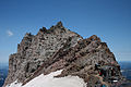
 Just below the summit of Mount Rainier, the Emmons Glacier stretches to the left of the Steamboat Prow (middle), which separates it from the Winthrop Glacier (right). |
||
| location | Pierce County , Washington , USA | |
| Mountains | Cascade chain | |
| Type | Plateau glacier | |
| length | Estimated 6.3 km | |
| surface | 11 km² | |
| Coordinates | 46 ° 51 '44 " N , 121 ° 43' 1" W | |
|
||
| drainage | White River → Puyallup River | |
| particularities | ends at a moraine; declining | |

The Emmons Glacier is located on the northeast flank of Mount Rainier in Washington State . At 11 square kilometers, it has the largest surface area of all glaciers in the Continental United States . The glacier was named after the geologist Samuel Franklin Emmons , who was involved in the exploration of Mount Rainier in 1870.
Beginning at an altitude of over 13,800 ft (4,206 m), the Emmons Glacier flows eastward to the valley. Near the Disappointment Cleaver at 12,200 ft (3,719 m), the Emmons glacier joins the Ingraham glacier coming from the south. The glaciers flow together down the valley and remain united until the wedge of Little Tahoma Peak . As the Emmons flows northeast down the valley, it reaches its end point at approximately 5,100 ft (1,554 m) altitude.
In the 1930s, the glacier appeared to be retreating very quickly. However, a landslide from Little Tahoma Peak in 1963 covered the lower glacier with debris. This layer of rubble kept the ice from melting. Due to the reduced melting, the glacier increased in size in the 1980s. This continued until 1992, albeit at a lower rate. The ice near the scree melted irregularly and formed an area with many bumps. By 2003 the glacier was receding again. "In the last few decades the glaciers [in the American West] have been disappearing and continuing the trend of the Little Ice Age."
The Emmons Glacier is often used as an ascent route (Columbia Crest Route) to the summit of Mount Rainier. There is a ranger station at Camp Schurman, which was built on the edge of the Steamboat Prow.

The Emmons Glacier on Mount Rainier at sunrise from the road

Glacier tongue of the Emmons glacier
The Camp Schurman ranger station on the Emmons Glacier on Mt. Rainier, WA
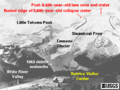
Illustration of the area around the Emmons Glacier


Individual evidence
- ↑ TopoQwest ( United States Geological Survey Maps). Mount Rainier East, WA [map]. Retrieved December 15, 2012.
- ^ A b Andrew G. Fountain, David Percy, Frank Granshaw: Glaciers of the American West (= Geological Society of America 2003 Seattle Annual Meeting) November 2, 2003 (accessed December 15, 2012).
Web links
- Emmons Glacier ( English ) In: Geographic Names Information System . United States Geological Survey . Retrieved December 15, 2012.