
Erebus glacier tongue
| Erebus glacier tongue | ||
|---|---|---|
 Satellite image of the glacier tongue. The so-called teeth on the edges are clearly visible. |
||
| location | Ross Island ( Ross Archipelago , Antarctica ) | |
| Coordinates | 77 ° 42 ′ S , 166 ° 40 ′ E | |
|
||
| drainage | Erebus Bay | |

The Erebus Glacier Tongue ( English Erebus Glacier Tongue ) in the Antarctic Ross Sea is the extension of the Erebus Glacier on the Ross Island . The glacier tongue begins at the northwest end of the Hut Point Peninsula , where the Erebus Glacier, which flows down the southern slope of Mount Erebus , reaches the sea, and extends west for several kilometers into Erebus Bay .
The glacier tongue is named after the Erebus Glacier on Mount Erebus, which is named after the ship HMS Erebus of the British polar explorer James Clark Ross (1800–1862).
Web links
- Erebus Glacier Tongue in the Geographic Names Information System of the United States Geological Survey (English)
- Erebus Glacier Tongue on geographic.org
Individual evidence
- ^ G. Holdsworth (1974): Erebus Glacier Tongue, Mcmurdo Sound, Antarctica . Journal of Glaciology, Vol. 13, No. 67, 27-35. P. 27. PDF
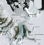
Satellite image of the area with labeling

The Erebus glacier tongue in the frozen Erebus Bay with the Dellbridge Islands (center) and Cape Evans (top right)

