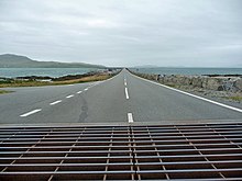
Eriskay Causeway
The Eriskay Causeway is a road embankment that connects the Hebridean islands of Eriskay and South Uist . It is the southernmost link in a network of dams and bridges that connects the largest islands in the archipelago. With a length of about 1.5 km it crosses the Eriskay Sound , which separates the two islands from each other.
Construction of the road embankment began in 2000. It required funding of the order of £ 9.4 million . This is the most expensive civil construction project that has ever been carried out in the Outer Hebrides. The dam begins in the north on a cape near the Ludag settlement on South Uist and reaches Barra near the Haun settlement . The Earl and Countess of Wessex appeared at the opening on September 11, 2002 . In contrast to other large road embankments between islands in the Outer Hebrides, such as the South Ford Causeway or the North Ford Causeway , the road on the Eriskay Causeway is consistently two-lane, with the embankment being about ten meters wide.
Individual evidence
- ↑ a b c Entry in the Gazetteer for Scotland
- ↑ Entry on cne-siar.gov.uk ( Memento of the original from February 27, 2014 in the Internet Archive ) Info: The archive link was inserted automatically and has not yet been checked. Please check the original and archive link according to the instructions and then remove this notice.
Web links
Coordinates: 57 ° 5 ′ 51 ″ N , 7 ° 19 ′ 3 ″ W.

