
Esch-Sauer
| coat of arms | map |
|---|---|

|

|
| Basic data | |
 Esch an der Sauer with church and castle |
|
| State : |
|
| Coordinates : | 49 ° 55 ' N , 5 ° 56' E |
| Canton : | Wiltz |
| Residents : | 2715 (January 1, 2019) |
| Area : | 6.76 km² |
| Population density : | 401.6 inhabitants / km² |
| Municipality number: | 0802 |
| Website: | www.esch-sur-sure.lu |
| politics | |
| Mayor: | Marco Schank |
| Elective system : | Majority vote |
Esch-Sauer ( Luxembourgish also Esch am Lach , French Esch-sur-Sûre ) is a municipality in the Grand Duchy of Luxembourg and belongs to the canton of Wiltz .
composition
The following places belong to the municipality:
- Bonnal (fr. Bonnal , lux. Bommel )
- Burgfrid (French Bourgfried , lux.Burfelt or Buergfrid ),
- Dirbach (French Dirbach , lux. Dierbech ),
- Eschdorf (French Eschdorf , lux.Eschduerf ),
- Esch-Sauer (French Esch-sur-Sûre , lux.Esch -Sauer ),
- Heiderscheid (French Heiderscheid , lux. Heischent ),
- Heiderscheidergrund (French Heiderscheidergrund , lux. Heischtergronn ),
- Hierheck (French. Hierheck , lux. Hierheck ),
- Insenborn (French Insenborn , lux. Ënsber ),
- Lultzhausen (French Lultzhausen , lux.Lëlz ),
- Merscheid (French Merscheid , lux. Metscheed ),
- Neunhausen (French Neunhausen , lux. Néngsen ),
- Ringel (French. Ringel , lux. Réngel ),
- Tadler (French. Tadler , lux. Toodler ).
The town hall is located in Eschdorf. The municipality is a member of the following municipal associations: DEA, Oewersauer Nature Park, SIDEC, SIDEN, SIGI and SYVICOL.

The place is located below a castle ruin on the Sauer in the Ösling region in northern Luxembourg (Luxembourg Ardennes). To the west of the village is the Obersauer reservoir , through which the Sauer flows. Both the lake and the community are part of the Obersauer Nature Park , an attraction for tourists and bathers. The reservoir can be used for sailing, canoeing, swimming, diving and fishing; Motorboat rides are prohibited. Nature conservation programs for fauna and flora are implemented around the lake.
coat of arms
In the quartered coat of arms, a green tree with nine golden fruits changes, behind which a black, red-tongued boar runs with five red bars .
history
Esch-Sauer and its surroundings look back on more than five thousand years of history. In the years 773/774, the former city is mentioned in connection with the donation of parts of the "Villa Hesc" to the Echternach monastery in the " Liber aureus Epternacensis " (fol. 78). These are the possessions of a certain Nebelungus:
- "Ego in Dei nomine Nebelungus pro Dei intuitu et pro remedio anime mee ad ecclesiam sancti Willibrordi dono res meas in villa que vocatur Hesc, quicuid ibidem visus sum habere, id est mansos IIII cum omnibus suis appandiciis, id est tam terris, casis, campis , pratis, pascuis, silvis, aquis aquarumve decursibus, mancipiis. Si quis vero de heredibus meis qui hanc donationem infringere voluerit, iram Dei incurrat. Actum anno III regnante Karolo brisk. "
This is probably where the name of Esch comes from. With the construction of the "Asko" castle (927), Esch-Sauer was a walled central place with town charter and an associated county in the Ardennergau from the earliest Middle Ages.
- Second World War
Until the beginning of the Second World War , Esch-Sauer belonged to the Diekirch district in what was then the Grand Duchy of Luxembourg. On May 10, 1940, at the beginning of the German campaign in the west , it was occupied by the Wehrmacht along with the entire district and from then on was under German military administration. From December 1, 1940, Esch-sur-Sûre was incorporated into the newly created district of Diekirch . In September 1944, US troops ended the German occupation.
Tourism - nature tourism
The area around Esch-Sauer is characterized by a wooded hilly landscape, the predominant rocks are slate and quartzite. The area's hallmarks are extensive slate rock walls, often piled up by geological faults.
The heart of the Obersauer Nature Park, which was officially opened in 1999, is the Nature Park Center, which is located in a two-hundred-year-old former cloth factory. An exhibition with machines, some of which date from the beginning of the 20th century, shows the process of fabric production from raw wool to the finished product. With the production of fabric covers and items of clothing, the craft heritage of the region is still alive today.
Various educational hiking trails are offered. There is also information about the national hiking trails as well as leisure and accommodation options.
A special attraction is the ride on the solar boat.
photos

Castle with village

Castle and village around 1860
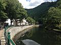
Sour in Esch-Sauer
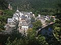
The locality

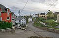
Heiderscheid
Merscheid


Individual evidence
- ↑ STATEC Luxembourg - Population par canton et commune 1821–2019 (French)
- ↑ Annuaire des communes: Esch-sur-Sûre ( Memento of the original of March 5, 2016 in the Internet Archive ) Info: The archive link was inserted automatically and has not yet been checked. Please check the original and archive link according to the instructions and then remove this notice. (PDF file; 22 kB), Syvicol .
- ↑ Nature Park Center . ( Page no longer available , search in web archives ) Info: The link was automatically marked as defective. Please check the link according to the instructions and then remove this notice.
- ↑ Solar boat around Séi.