Espargos
| Espargos | ||
|---|---|---|
|
|
||
| Coordinates | 16 ° 44 ′ N , 22 ° 56 ′ W | |
| Basic data | ||
| Country | Cape Verde | |
|
Archipelago |
Ilhas de Barlavento | |
| District | Sal | |
| ISO 3166-2 | CV-SL | |
| Residents | 6173 (January 1, 2005) | |
|
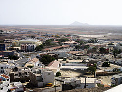
Espargos seen from the radar station, looking south-west
|
||
Espargos (derived from the Portuguese : espargo "asparagus") is the capital of the island of Sal , one of the nine inhabited islands of the Republic of Cape Verde .
geography
Espargos is in a central position in the middle of the small island and immediately north of the international airport " Aeroporto Internacional Amílcar Cabral " ( IATA code : SID). The island's capital is a calculation from 2005, according to 6137 inhabitants, the second largest town on Sal At the entrance all paved roads of the island converge. The main link to the south leads past the airport and in the holiday resort Murdeira up in the real tourist center of Santa Maria on the south coast. Other roads connect Espargos with the small village of Pedra de Lume on the east coast and with Palmeira , the port of Sal, on the west coast. You can also go further into the uninhabited northern part of the island via sand tracks.
The city was built around the local mountain, the 107 m high Monte Curral . The desert-like landscape is flat and level all around, as is typical for Sal. The summit of the volcanically formed Monte Curral was leveled. The radar station , which is used to monitor air traffic, and some transmission masts , which supply the island with radio programs and the mobile telephone network , are now located on its top . The town center is on the southwest flank of the mountain. There are u. a. the local church, the market hall and the island administration.
history
When the Cape Verde Islands were discovered and settled in the 15th century , the habitat on the coasts was first developed, where the first settlements arose. Espargos, on the other hand, is quite young. The place was created at the time of the Second World War . In 1939, Mussolini had secured the right to build a transit airport between Europe and South America on the island of Sal from the Portuguese colonial government . Towards the end of the war, a cluster of residential barracks was built on Monte Curral north of the airport, from which the place later developed. Espargos has grown a lot since then. The name of the place is derived from the wild asparagus that grows around the city in the rare event that it rains on Sal. However, the asparagus is inedible.
As a result of the course of the war, the Italians had to quickly withdraw from the airport project. However, the Portuguese government took over the continuation of the construction in 1945. Four years later, a fully functional transit airport emerged, which has been continuously improved and expanded since then.
Population development
| year | population |
|---|---|
| 1990 ( June 23 , census) | 5,778 |
| 2000 ( June 16 , census) | 5,456 |
| 2003 (estimate) | - |
| 2005 ( January 1st , calculation) | 6,173 |
economy
Since all traffic routes converge in Espargos and the administration is also located here, the city is the economic center. Sal has neither significant deposits of raw materials nor its own production facilities. The determining economic factor is the airport, which makes Sal an international hub within Cape Verde. This was also decisive for the economically important tourism to establish itself on the island of Sal first.
Individual evidence
- ↑ a b Cape Verde Islands , Dumont travel paperback, 3rd edition, 2007, ISBN 3-7701-5968-3


