
Falkenhagener meadows
Coordinates: 52 ° 36 ′ 9.5 ″ N , 13 ° 2 ′ 59.5 ″ E

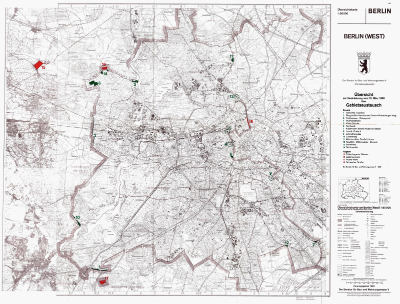
The Falkenhagener Wiesen are located in the northwest of Falkensee and until 1988 were an exclave of West Berlin on the territory of the former GDR . At 45.44 hectares, the area was by far the largest exclave in Berlin and, at around six kilometers, it was the furthest away from the city limits of Berlin.
The exclave was on the northeast side of Nauener Strasse, which connects Falkensee with Brieselang, northwest of the tracks of the Berlin outer ring and reached as far as the Havel Canal .
review
In the past, when property tax was paid for an area, this was assigned to the municipality in which the owners were resident. In the case of the Falkenhagener Wiesen it was the Kladow district of Spandau . With the formation of Greater Berlin in 1920, numerous exclaves were created on Brandenburg territory, which administratively belonged to Berlin, but were outside the contiguous urban area. They were preserved even after the end of World War II . As a result of the division of Germany in 1949, the situation became even more complicated, because now the areas were not just within a different municipality, but a different state. Since 1961, the Falkenhagener Wiesen was separated from the other parts of West Berlin by the Berlin Wall .
Part of the area was used for growing beets and grain until the 1980s. In contrast to the desert mark , for example , there were no markings or barriers in the area. Nevertheless, it was shown on public maps published in the GDR as "belonging to West Berlin".
After the Four Power Agreement in 1971, East and West tried to correct borders. Twice - in 1972 and again in 1988 - territorial exchanges were carried out between West Berlin and the GDR. In the latter case, the Falkenhagener Wiesen then fell to the GDR and are accordingly part of Brandenburg today.
Web links
Individual evidence
- ↑ Article "Through the Döberitzer Heide"
- ↑ Articles and maps on berlinweb.de
- ↑ a b Christian Simon: Berlin Grotesk. The wall in the absurd everyday life of a megacity. Christian Simon Verlag, Berlin 2011, ISBN 978-3-936242-14-0 , pp. 61-62.
- ↑ see e.g. B. Administrative map of the Potsdam district, 1: 200,000 , Tourist Verlag , Berlin / Leipzig 1981.