Faude
| Faude | ||
|---|---|---|
|
View from Lapoutroie |
||
| height | 773 m | |
| location | Haut-Rhin department , Grand Est region , France | |
| Mountains | Vosges | |
| Coordinates | 48 ° 8 '21 " N , 7 ° 9' 48" E | |
|
|
||
The Faudé ( 773 m ) is a mountain located between Orbey and Lapoutroie in Alsace in the Vosges .
tourism
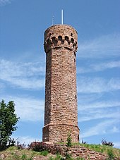
The top of the Faudé has a lookout tower . The first tower, 12 meters high, built between 1889 and 1891 by the Kaysersberg-Lapoutroie section of the Vosges Club , was destroyed in the fighting during the First World War in 1915. In 1934 the tower was rebuilt, now on an octagonal floor plan and with a height of 16.5 meters. This tower collapsed in 1944 as a result of artillery fire. In 1990 the idea arose to rebuild it; the reconstruction finally took place from 1999, the inauguration of the rebuilt tower on August 15, 2002. In 2005 a refuge ( abri du Faudé ) was set up.
Web links
Commons : Faudé - collection of images, videos and audio files


