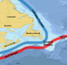
Flemish cap
The Flemish Cap (in English Flemish Cap ) is a shallow water area of the Atlantic Ocean about 560 km east of the city of St. John’s on Newfoundland .
geography
The shallow water area is formed by a submarine plateau, which is separated by a ditch from the Newfoundland Bank, which lies further to the south-west . The water depths in this area are between 122 and 700 meters. The size of the lake area is about 42,000 km². It is slightly smaller in area than the German state of Lower Saxony .
Water and current conditions
In the Flemish Cap area, the warm waters of the Gulf Stream mix with that of the colder Labrador Stream , creating a current that circulates clockwise over the sea area.
The water in the Flemish Cap area is warmer than in the neighboring Newfoundland Bank. It is therefore assumed that marine organisms that are sensitive to the cold were able to survive the ice ages here.
fishing
Today the area is considered an important fishing ground. Halibut , swordfish , shrimp and scallops can be caught there.
The Flemish Cap is outside of the exclusive economic zone claimed by Canada in international waters. Like many other fishing areas, it is affected by overfishing , which manifests itself in a massive decline in stocks of redfish , cod and other fish species, for example .
Movie
The Flemish Cap was the last fishing ground of the swordfish cutter Andrea Gail before it went down in a heavy storm. This was taken up in the film " Der Sturm " by Wolfgang Petersen .
