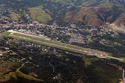
Jayapura Airport
| Sentani Airport (Jayapura) | |
|---|---|

|
|
| Characteristics | |
| ICAO code | WAJJ |
| IATA code | DJJ |
| Coordinates | |
| Height above MSL | 88 m (289 ft ) |
| Transport links | |
| Distance from the city center | 1.5 km southwest of Sentani (Jayapura) , 23 km west of Jayapura , 3755 km east of Jakarta |
| Basic data | |
| opening | 1943 |
| Start-and runway | |
| 12/30 | 3000 m × 45 m asphalt |
Sentani International Airport ( Indonesian Bandar Udara Sentani , IATA : DJJ, ICAO : WAJJ) is located on Lake Sentani , about 23 km west of the city of Jayapura , the capital of the Indonesian province of Papua on the island of New Guinea . It is currently only served by domestic flights.
In October 2012, plans were announced to expand the airport runway from 2500 meters to 3000 meters and to build a parallel taxiway. In addition, the passenger terminal should be expanded and equipped with passenger boarding bridges . The expansion measures were completed at the end of 2015.
Web links
Commons : Jayapura Airport - Collection of images, videos and audio files
- Airport data on World Aero Data ( 2006 )
Individual evidence
- ↑ a b Several airports coming up in Papua. In: Antara News . October 8, 2012, accessed January 9, 2019 .
