
Nowy Targ Airfield
| Lotnisko Nowy Targ | |
|---|---|

|
|
| Characteristics | |
| ICAO code | EPNT |
| IATA code | QWS |
| Coordinates | |
| Height above MSL | 628 m (2060 ft ) |
| Transport links | |
| Distance from the city center | 1 kilometer (s) from Nowy Targ |
| Street | DK49 , DK47 |
| Basic data | |
| opening | 1930 |
| operator | Aeroclub Nowy Targ |
| Terminals | 1 |
| Start-and runway | |
| 12/30 | 1677 m × 30 m grass |
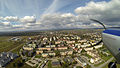
The airfield Nowy Targ is a flying club of Aeroklub Nowy Targ and a proud 100-year tradition. It is located around one kilometer south of Nowy Targ and around 20 kilometers north of Zakopane in the Polish region of Podhale , specifically in the Kotlina Nowotarska valley basin at the foot of the High Tatras . At almost 630 m above sea level, it is the highest airfield in Poland.
history
In the 19th century, the army of the K-and-K monarchy had a military training area on the site of today's airfield. Observation balloons took off from the airfield before the First World War. After the First World War, the Polish Air Force used the airfield until it was handed over to civil aviation in 1930. Until the Second World War it was used as a sports airfield. During the Second World War, the German Air Force used it to take action against resistance fighters in the surrounding mountains. After the Second World War it was used again as a sports airfield. On June 8, 1979, Pope John Paul II celebrated a mass on his first trip to Poland in front of approximately one million believers on the airfield. The airfield is currently used by the Nowy Targ Aeroclub and Skoczek Parachuting Club. It is considered to expand the airfield and open it to regular traffic.
gallery
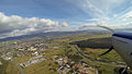
Landing approach

Landing approach
begin
.jpg)

