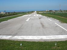
Ragusa-Giubiliana airfield
| Ragusa-Giubiliana airfield | |
|---|---|

|
|
| Characteristics | |
| Coordinates | |
| Height above MSL | 427 m (1401 ft ) |
| Transport links | |
| Distance from the city center | 10 km southwest of Ragusa |
| Street | SS115 , SP60, SP25 |
| Local transport | bus |
| Basic data | |
| opening | 1994 |
| surface | 6 ha |
| Start-and runway | |
| 07/25 | 700 m × 20 m asphalt |
The airfield Ragusa-Giubiliana is for light aircraft certified aerodrome ( Aviosuperficie , ENAC code: RGGIU) on the Italian island of Sicily . The airfield is located nine kilometers from Ragusa at an altitude of 427 meters above sea level and has an area of six hectares. The 700 meter long runway 07/25 is paved. The tower frequency is 131.05 MHz.
The airfield is used exclusively for tourist purposes. Its location in the center of the Mediterranean makes it a popular destination for European private pilots. The operating company are the Nifosì Tourist Companies. In the northern part of the site there is a small necropolis from the period between the 3rd and 5th centuries BC.
Facilities
- Shuttle bus to Ragusa and the sea
- Hotel and restaurant
- hangar
- Aircraft workshop
- Fuel: Avgas 100 / LL and Mogas
- Car rental
- parking spot
- Slope service
Others
In the vicinity of the Ragusa-Giubiliana airport, near Comiso and Marina di Ragusa , there are three other airports for general aviation. Comiso Airport , which reopened in 2013, is also open to light aircraft.
