Fort Massachusetts (Mississippi)
| Fort Massachusetts | ||
|---|---|---|
|
|
||
| Location: | Mississippi , United States | |
| Next city: | Gulfport, Mississippi | |
Fort Massachusetts was a coastal defense fort in the state of Mississippi on West Ship Island 12 miles across from the port city of Gulfport in Harrison County . It was supposed to protect Gulfport and cordon off the Santa Rosa Coastal Waterway that began here .
The construction
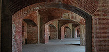
It is a roundabout made of bricks , the base of which forms a little more than a semicircle and which is sealed off in the throat by a hollow crossbeam as a defensive barracks. The battery pack was pulled around the throat area, so that two throat cases were formed to protect the entrance area. The complex was not surrounded by a ditch. Guns could be set up on two levels, both in the casemates and on the bench (on the deck of the battery block). Due to the semicircular design of the work, the shooting direction from south to north was possible, but the fort was oriented to the west. It was purely an artillery combat plant, as there were no defensive devices against infantry attacks except for the two throat cases to protect the gate area.
The bricks needed for the construction came from Louisiana until the secession , after the resumption of the construction work still during the Civil War the stones were delivered from New England and after the end of the war the stones were obtained again from Louisiana. This can be clearly seen from the different colors in the masonry.
history
After the British-American War of 1812, the US Department of War began planning the construction of several masonry fortifications for coastal defense. Due to its location on the Santa Rosa Waterway, Ship Island seemed a favorable location, as the protection of the Mississippi estuary and thus New Orleans were also included in the considerations.
In 1847 the island was declared a restricted military area, and in 1856 Congress approved the construction of a fort . Under the auspices of the Army Corps of Engineers , construction began in 1859 at a location 500 feet (150 meters) east of the tip of the island. Most of the work was carried out by civilian craftsmen (in contrast to the forts built earlier such as Fort Pickens , no more slaves seem to have been used here, at least there is no information about this). Up to 100 bricklayers, stonemasons, carpenters and blacksmiths worked on the building at the same time. In January 1861, when Mississippi joined the Confederation and construction was stopped by the US military, the outer wall was raised up to eight feet. The Mississippi militia occupied the island and the unfinished fort, but left it again after a short time. It was not until June 1861 that the island was occupied again, this time by regular troops of the Confederate forces and equipped with some cannons. The first and only act of war took place on July 9, 1861, when the frigate USS Massachusetts fought a twenty minute artillery duel with the fort, with both sides getting away lightly and without great losses.
During the summer months, the Confederates reinforced the unfinished fort with logs and sandbag barriers, but nevertheless withdrew from the island in mid-September. The US troops immediately occupied the island and built it into a base for their operations against the south of the Confederation. The island played an important role in the capture of New Orleans in the spring of 1862.
As early as 1862, the Army Corps of Engineers resumed the construction work that had been interrupted the previous year. In the autumn of 1866 the work was finished and, as is customary in peacetime, the facility was handed over to a civilian fort keeper named CH "Pop" Stone . After the fort had been reinforced with additional cannons, a sergeant of the US Ordnance Corps was given the supervision of the cannons, possibly even of the entire fort. In 1903 the fort was abandoned and the lighthouse keeper of Ship Island had to supervise the structure in the future.
restoration
Due to its location directly on the water, the impact of the waves and the salty air, the system fell into disrepair. In the northern section in particular, the sand was washed away so that the walls were directly in the water. In the 1960s, Mississippi state citizens formed a "Save the Fort" movement to save the fort. In the meantime, the National Park Service had removed sand from the fairway with suction dredgers and washed up a beach in front of the fort. In 2001 a group of specialists from the National Park Service restored parts of the damaged ramparts. The beach was overgrown to protect the island.
The fort is a historic tourist attraction within the Gulf Islands National Seashore and is under the administration of the National Park Service .
Naming
The fort, officially called "Fort on Ship Island", was first referred to as Fort Massachusetts during the Civil War, possibly in memory of the battle of the USS Massachusetts. Fort Massachusetts is naturalized and used exclusively.


