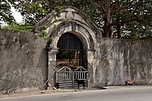
Fort Maubara
The Fort Maubara is a small, colonial fortress in the East Timorese town Maubara ( Suco Vaviquinia , Office of Administration Maubara , community Liquiçá ). The rectangular fort , on the wall of which there are still two cannons, is the town's most striking structure. It is located directly at the entrance to Maubara, on the well-developed thoroughfare, from where you can overlook the entire bay on the beach. The fort is owned by the state but managed by the Maubara Association Mós Bele .
history
In 1667 Maubara allied itself with the Dutch , who in 1756 built the fortress to secure their colonial claims. Maubara became a Dutch enclave in Portuguese Timor . In 1758 two ships from Sikka , which was allied with Portugal , attacked Maubara. The Dutch East India Company (VOC) responded by sending two ships from Kupang to support Maubara's ruler, José Xavier Doutel. After the successful defense, a unit of a hundred European and Balinese soldiers, under the command of Jacob Pietersz, was sent to Maubara to expand the fort. The enclosure was now eighty feet in diameter and the walls six feet thick. But this was not enough as a deterrent. When Pietersz returned to Maubara with fresh soldiers in 1759, he again had to defend the empire against unnamed attackers. The next Portuguese attack took place in 1760. A VOC ship with Mardijkern came to help Maubara. In that year, the German VOC commander Hans Albrecht von Plüskow was killed. As a result, in 1761 the crew from Fort Maubara was almost completely ordered back to Kupang. Only twelve European soldiers remained. Doutel therefore asked for reinforcements in Kupang and Batavia . To add to the emphasis, he sent large quantities of sandalwood and beeswax as gifts. The years that followed remained unsettled. In 1790, the Topasse ruler Pedro da Hornay attacked Maubara on behalf of Portugal. The attack was repulsed. The only thing the Topasse achieved with the action was that Maubara renewed its alliance with the Netherlands and set the flag of the Netherlands . From 1796 to 1799 Maubara was again at war with the Portuguese , together with Gross-Sonba'i .
In the Treaty of Lisbon in 1859, however, the Dutch agreed to cede Maubara to the Portuguese as part of a larger exchange of territory. The handover took place in April 1861. In 1869 the captain of the Portuguese corvette Sa de Bandeira described the fortal's building made of loose stones, close to the sea shore, which at that time was only equipped with a single, rusty cannon. Maubara revolted against the Portuguese several times until 1893. In 1889 a customs post was established in Maubara. The customs house is still located opposite the fort today.
The building inside the fortress dates from the second half of the 20th century and served as the seat of the local administration. Today it houses a restaurant.
See also
Web links
Individual evidence
- ↑ a b Architectural heritage of portuguese origins of Liquiça. , Pp. 95–98, Dili 2013. (Portuguese, tetum , English)
- ↑ a b Geoffrey C. Gunn: History of Timor ( Memento of the original from March 24, 2009 in the Internet Archive ) Info: The archive link was inserted automatically and has not yet been checked. Please check the original and archive link according to the instructions and then remove this notice. , P. 50ff.
- ↑ Chronologie de l'histoire du Timor (1512-1945) suivie des événements récents (1975-1999) (French; PDF; 867 kB)
- ↑ Fernando Augusto de Figueiredo: Timor. A presença portuguesa (1769-1945) (PDF; 66.18 MB)
- ^ Douglas Kammen: Three Centuries of Conflict in East Timor , 2015.
Coordinates: 8 ° 36 '39.4 " S , 125 ° 12' 17.2" E


