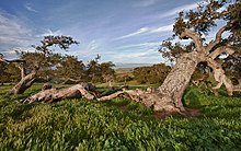
Fort Ord National Monument
The Fort Ord National Monument is a US National Monument in Monterey County in California . It was designated by President Barack Obama by a Presidential Proclamation on April 20, 2012 with an area of 14,651 acres . The National Monument covers the hinterland of the United States Army's Fort Ord training area, which is now closed . The Fort Ord Dunes State Park includes the coastal part of the former military training area. The Fort Ord Dunes State Park with an area size of 980 acres (400 ha ) was recorded in 2009. Both sanctuaries are separated by settlement areas, which used to be part of the military training area and are now used by California State University, Monterey Bay and for commercial purposes. The Bureau of Land Management (BLM) is responsible for the management. The BLM only managed 7200 acres in 2012. In the remaining area, the US Army must first clear all duds before the BLM can take over these areas.
Renaturation and habitats of the National Monument
The area of the military training area once housed 15 shooting ranges, including those for guns and tanks of the Army. In the ongoing renaturation by the US Army, soil containing lead is being removed, especially at the shooting ranges, and the area is being cleared of ammunition or ammunition residues. The Army has recovered leaded soil and 719,000 pounds of ammunition debris from 162,800 yards. Due to the ammunition residues, parts of the area are closed to visitors and hikers are not allowed to leave some hiking trails. There are currently more than 86 miles of trails available for hikers, cyclists and riders.
In the reserve there are chaparral , oak forests and grasslands with a great variety of plants and animals. There are endangered species like Smith's blue butterfly ( Euphilotes enoptes smithi ), California tiger newt ( Ambystoma californiense ) and Contra Costa goldfields ( Lasthenia conjugens ). The occurrence of rare and endemic plant and animal species should be promoted through a management plan. It is one of the few remaining places in the world where large areas of coastal chaparral, oak forests and savanna habitats exist mixed together.
Fort Ord training area
The US government bought 15,000 acres of land for the training of soldiers in 1917. In Camp Gigling , field exercises were conducted, as well as training of cavalry and field artillery units stationed in Presidio . In 1933, the Army renamed the training area Camp Ord . The name was given after Major General Edward Otho Cresap Ord , who had fought for the Union in the Civil War. The exhibition halls and cavalry horse stables were the first permanent structures built in the fort in 1938. Camp Ord was renamed Fort Ord in 1940 and expanded with barracks and an airfield. During World War II, the Korean War, and the Vietnam War, Fort Ord was one of the Army's main training bases. More than 1,500,000 soldiers were trained at Fort Ord between 1940 and 1973. From 1940 to 1994 the 7th Infantry Division was stationed intermittently at Fort Ord. In 1991 the US Army began preparing for the closure and in 1994 the closure took place. The US Army continues to exercise in a small area of the former military training area.
Web links
Individual evidence
- ^ A b Presidential Proclamation - Establishment of the Fort Ord National Monument
- ↑ a b Fort Ord Dunes State Park
- ↑ Fort Ord National Monument, Trail Map and Guide
Coordinates: 36 ° 36 ′ 33.1 " N , 121 ° 45 ′ 33.2" W.


