Fort Pierre
| Fort Pierre | |
|---|---|
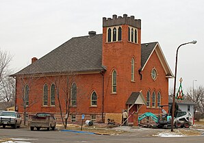
 United Church of Christ Congregational at Fort Pierre |
|
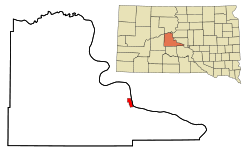
| Location in South Dakota | |
| Basic data | |
| State : | United States |
| State : | South Dakota |
| County : | Stanley County |
| Coordinates : | 44 ° 22 ′ N , 100 ° 23 ′ W |
| Time zone : | Central ( UTC − 6 / −5 ) |
| Residents : | 2,078 (as of 2010) |
| Population density : | 258.1 inhabitants per km 2 |
| Area : | 8.18 km 2 (approx. 3 mi 2 ) of which 8.05 km 2 (approx. 3 mi 2 ) is land |
| Postal code : | 57532 |
| Area code : | +1 605 |
| FIPS : | 46-22260 |
| GNIS ID : | 1255113 |
Fort Pierre is a parish in South Dakota and the administrative seat of Stanley County in the United States. Fort Pierre is on the west bank of the Missouri River across from Pierre, the capital of South Dakota. Fort Pierre was named after the French fur trader Pierre Chouteau. According to a 2010 census, Fort Pierre had 2,078 inhabitants spread over 893 households.
Individual evidence
Web links
Commons : Fort Pierre - collection of images, videos and audio files
- Official site of the community (English)
