
Fort Randall Dam
| Fort Randall Dam | |||||||||
|---|---|---|---|---|---|---|---|---|---|
 |
|||||||||
|
|||||||||
|
|||||||||
| Coordinates | 43 ° 4 ′ 0 ″ N , 98 ° 33 ′ 0 ″ W | ||||||||
| Data on the structure | |||||||||
| Lock type: | dam | ||||||||
| Construction time: | 1946-1956 | ||||||||
| Height of the barrier structure : | 52 m | ||||||||
| Building volume: | 38.227 million m³ | ||||||||
| Crown length: | 3 261 m | ||||||||
| Power plant output: | 320 MW | ||||||||
| Data on the reservoir | |||||||||
| Water surface | 413 km² (or 346 km² or 479 km²) | ||||||||
| Reservoir length | 171 km | ||||||||
| Storage space | 5700 million m³ (or 7000 million m³) | ||||||||
| Catchment area | 682,410 km² | ||||||||

The Fort Randall Dam (English: Fort Randall Dam ) is a dam that dams the Missouri in South Dakota to the reservoir Lake Francis Case .
The dam is part of the “Pick Sloan Program” dam project to develop water resources in the Missouri area. The construction of the dam was decided in the Flood Control Act of 1944. The US Army Corps of Engineers began construction of the dam in 1946. President Dwight D. Eisenhower pressed the button to generate electricity for the first time in 1954. When completed in 1956, the cost of the dam and the reservoir at 200 million were US dollars .
The dam is in southeastern South Dakota within sight of the eponymous Fort Randall near Pickstown (South Dakota) 19 km west of Wagner on South Dakota Highway 46 and 40 km northeast of Spencer (Nebraska) on US Highway 281. The name comes from Colonel Daniel W. Randall, who was a former treasurer in the Army. The reservoir is named after former South Dakota MP and Senator Francis H. Case . It extends 171 km to Big Bend Dam at Fort Thompson.
The eight generators of the hydropower plant can each generate 40 MW, that makes a total of 320 MW. That's enough to supply 245,000 households with electricity.
For the water area of the reservoir there are contradicting data of 413 km², 346 km² or 479 km², for the storage contents 5700 million m³ or 7000 million m³ are given.
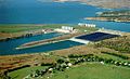
Aerial view of the dam and the reservoir

Location of the dams of the Pick Sloan project and the Indian reservations affected by flooding


See also
- List of the largest dams on earth
- List of the largest reservoirs on earth
- List of the largest hydroelectric plants in the world
- List of dams in the United States
Web links
- Fort Randall Dam & Lake Francis Case on the Army Corps of Engineers website
![]() Toston |
Canyon Ferry |
Hauser |
Holter |
Black Eagle |
Rainbow |
Cochrane |
Ryan |
Morony |
Fort Peck |
Garrison |
Oahe |
Big Bend |
Fort Randall |
Gavins Point
Toston |
Canyon Ferry |
Hauser |
Holter |
Black Eagle |
Rainbow |
Cochrane |
Ryan |
Morony |
Fort Peck |
Garrison |
Oahe |
Big Bend |
Fort Randall |
Gavins Point