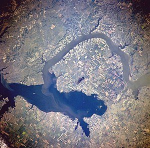
Lake Sakakawea
| Lake Sakakawea Garrison Dam |
|||||||||
|---|---|---|---|---|---|---|---|---|---|
| Satellite image from an altitude of 385 km (July 1996) | |||||||||
|
|||||||||
|
|
|||||||||
| Coordinates | 47 ° 29 '59 " N , 101 ° 25' 2" W | ||||||||
| Data on the structure | |||||||||
| Construction time: | 1947-1956 | ||||||||
| Height of the barrier structure : | 62-64 m | ||||||||
| Building volume: | 50.843 million m³ | ||||||||
| Crown length: | 3444-4000 m | ||||||||
| Power plant output: | 515 MW | ||||||||
| Data on the reservoir | |||||||||
| Water surface | 1489–1578 km² | ||||||||
| Reservoir length | 286 km | ||||||||
| Maximum depth | 55 m | ||||||||
| Storage space | 27,920–31,100 million m³ | ||||||||
| Design flood : | 23,418 m³ / s | ||||||||
The Lake Sakakawea is a reservoir in North Dakota in the United States . The Missouri is shortly after the somewhat broader Yellowstone River has received, from the Garrison Dam ( ⊙ dammed), who after the small town of Garrison is named in North Dakota. The dam is named after the Indian Sacajawea . The dam and lake are used for flood protection , electricity generation, navigation, irrigation and fish farming. The Garrison Dam was built from 1946 as the first part of the large-scale Missouri Dam Project Pick-Sloan Missouri Basin Program . He had a devastating impact on the Indian reservation Fort Berthold Reservation .
Reservoir
After the water is the reservoir of the second largest in the US after the Lake Powell and after the memory contents, it is the third or fourth largest after Lake Mead , the Lake Powell and - depending on actual memory contents - including the Lake Oahe . The reservoir is located about 80 km from Bismarck , North Dakota. The glacier ice reached this far in the Ice Age .
The reservoir is 286 km long, on average between three and five km and a maximum of 10 km wide, has a shoreline of 2000 km and a storage capacity, which is stated differently with 27.9 to 31.1 billion cubic meters. The maximum water depth at the dam is 55 m.
Lake Sakakawea flooded large parts of the Fort Berthold Reservation .
dam
The "Garrison Dam" located in the Indian reservation near Riverdale and Pick City is (after the Fort Peck Dam, which was commissioned in 1940 ) the second and to this day the largest of the dams on the Missouri. The earthfill dam was built and operated by the US Army Corps of Engineers . In June 1953 it was inaugurated by President Dwight D. Eisenhower ; the earthworks were finished in 1954 and the remaining construction work lasted until 1956. The dam is one of the largest in the world with its volume of 50.845 million m³, a height of 62 (or 64) m and a length of 3444, possibly even 4000 m.
The dam cost $ 300 million to build. To fill it up, nine million truckloads of earth were transported or 60,000 m³ daily.
Hydroelectric power plant
The turbines of the hydropower plant on the dam have an electrical generator capacity of 515 megawatts . On average, they produce 240 MW, which is enough for several hundred thousand people.
Fish farming
Fish are also raised in the reservoir. There is the largest breeding station for glass eye bass and pike , the Garrison Dam National Fish Hatchery. Endangered species such as the white shovel sturgeon are also reared.
Effects on Indian territories
Lake Sakakawea on the Fort Berthold Reservation caused the greatest damage of any dams built under the Pick Sloan program. The reservation is home to the Mandan , Hidatsa and Arikaree nations (since 1934 the Three Affiliated Tribes have been united ). The reservoir flooded over 25 percent of their land. The Indian tribes lost around 617 square kilometers (152,360 acres ) of their area. Although this is a smaller area than the Sioux later lost to the Lake Oahe reservoir , the effects on the Indian population on the Fort Berthold reservation were more devastating: around 80 percent of all tribal members had to resettle. They lost 94% of their agricultural land .
Missouri dams
Other dams built on the Missouri as part of the Sloan Pick Project between 1946 and 1966 include Canyon Ferry Lake in Montana and Oahe , Big Bend Dam , Fort Randall and Gavins Point Dam in South Dakota . Older Missouri dams include the Hauser Dam (1907) and the Fort Peck Dam (1940) in Montana,
See also
Web links
- Garrison Dam & Lake Sakakawea on the Army Corps of Engineers website
- North Dakota Studies: Garrison Dam . In: The History and Culture of the Mandan, Hidatsa, and Sahnish
Individual evidence
- ↑ Michael L. Lawson: Dammed Indians: The Pick-Sloan Plan and the Missouri River Sioux, 1944-1980 . University of Oklahoma Press, 1994. ISBN 9780806126722
- ^ Robert Kelley Schneiders: Dams across the wide Missouri: Water transportation, the Corps of Engineers, and environmental change along the Missouri Valley, 1803-1993 . In: Retrospective Theses and Dissertations. Number 12242 , 1997
- ^ Robert Kelley Schneiders: Flooding The Missouri Valley The Politics Of Dam Site Selection And Design. In: Great Plains Quarterly 17, 1997. Pages 237-491


