
Früllbach
| Früllbach | ||
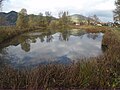
 Near the mouth of the Früllbach in the Ammer |
||
| Data | ||
| location | Upper Bavaria | |
| River system | Danube | |
| Drain over | Ammer → Isar → Danube → Black Sea | |
| Source height | approx. 830 m | |
| muzzle |
Ammer coordinates: 47 ° 36 '55 " N , 11 ° 2' 9" E 47 ° 36 '55 " N , 11 ° 2' 9" E |
|
| Mouth height | 826 m | |
| Height difference | approx. 4 m | |
| Bottom slope | approx. 2.5 ‰ | |
| length | about 1.6 km | |
The Früllbach is a brook in Upper Bavaria . It arises in the powder moss in two spring ponds and flows largely in a north-westerly direction to the mouth of the Ammer . There it flows in close proximity to a nameless pond.
gallery
Nameless pond near the mouth

Individual evidence
- ↑ Roughly measured on the Bavaria Atlas