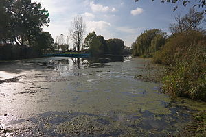
Franzsee
| Franzsee | ||
|---|---|---|

|
||
| Geographical location | Lower Saxony , Neustadt am Rübenberge | |
| Tributaries | Seegraben | |
| Drain | Seegraben | |
| Places on the shore | Amedorf | |
| Location close to the shore | Mandelsloh | |
| Data | ||
| Coordinates | 52 ° 35 '38 " N , 9 ° 34' 2" E | |
|
|
||
| surface | 0.6 ha | |
| length | 240 m | |
| Maximum depth | 4 m | |
| Middle deep | 3–4 m | |
The Franzsee is a dammed lake south of Amedorf , a district of Neustadt am Rübenberge in the Hanover region . The Franzsee which in the conservation area "Bottom line" is, is crossed by Seegraben which at Mandelsloh in the line ends. The lake has a boggy character with reeds and water lilies . It is surrounded by agricultural land .
The lake was created by mining clay to make bricks. Turf iron stone was also extracted here, from which the tower of the St. Osdag Church in Mandelsloh was built at the end of the 15th century .
The lake has been used as a bathing lake since 1934 . Later, a natural open-air swimming pool was built on the south bank of the lake with a lawn for sunbathing and a paved swimming area around 30 meters long with an entry ladder and slide. After the municipal pool was closed for cost reasons in 1996, the open-air pool resumed operation in 1997 through a specially founded association, the Franzsee Initiative eV. Today the Franzsee Initiative has around 500 members.
Web links
- Naturbad Franzsee , Franzsee Initiative e. V.
- Franzsee , Hannover.de
- Franzsee outdoor pool , Bathing Water Atlas Lower Saxony
Individual evidence
- ↑ a b Circular hiking trail Mandelsloh – Amedorf ( Memento from August 4, 2009 in the Internet Archive ), Projects of the Hannover Garden Region. Hannover.de.
- ^ The Franzsee Initiative , Franzsee Initiative e. V. Accessed January 27, 2017.
