
Freibergsee
| Freibergsee | ||
|---|---|---|

|
||
| Geographical location | District of Oberallgäu , Bavaria | |
| Drain | to Stillach | |
| Location close to the shore | Oberstdorf | |
| Data | ||
| Coordinates | 47 ° 22 '49 " N , 10 ° 16' 6" E | |
|
||
| Altitude above sea level | 930.8 m above sea level NN | |
| surface | 18 ha | |
| length | 526 | |
| width | 484 | |
| Maximum depth | 25 m | |
|
particularities |
highest bathing lake in Germany |
|

The Freibergsee is located in the south of Oberstdorf , the southernmost municipality in Germany, in the Oberallgäu district in Bavaria at an altitude of 930 m on the wooded Freiberg.
Lake and surroundings
The maximum water depth of the lake is about 25 meters, it is about 18 hectares in size. Its greatest length is 526 meters, its greatest width 484 meters.
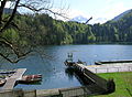
The lake is developed for tourism through a restaurant, beach café, bathing establishment and boat rental. In the south of the lake is the Heini-Klopfer ski jump , currently the fourth largest ski jump in the world.
- photos
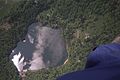
Freibergsee from a paraglider

View from the Heini-Klopfer ski jump Oberstdorf
Freibergsee, in the background the ski flying hill


.jpg)
Access
The lake can be reached next to a driveway over the hamlet of Schwand, which is closed to public traffic, etc. a. through the following hiking trails:
- Edmund-Probst-Weg (Kornau)
- Ziegelbachweg
- Away from the Renksteg
- Away from the Söllereck via Hochleite
Hydrology
In addition to smaller tributaries, it is assumed that springs at the bottom of the lake feed it. The Freibergsee has no surface drains, so it is a blind lake . The water seeps away or runs off through crevices.
See also
Web links
- Oberstdorf-Online: The Freibergsee
- Freibergsee - information about the lake on oberstdorf.de
Individual evidence
- ↑ a b Bavarian Surveying Administration : BayernAtlas . Retrieved October 28, 2014.
- ^ [1] Oberstdorf online, accessed November 29, 2010
- ↑ [2] all-in.de, accessed on June 27, 2020