Moordeich cemetery
The Moordeich cemetery is a municipal cemetery in the Stuhr municipality in the Diepholz district , Lower Saxony , on the southern border of Bremen . It was created between 1985 and 1990 and implements the concept of a park cemetery .
history
In 1984 the council of the municipality of Stuhr decided to build a new cemetery in the Moordeich district when it became apparent that the church cemeteries in Brinkum, Heiligenrode and Alt-Stuhr had reached their capacity limits. The community of Stuhr also maintains communal cemeteries in the districts of Fahrenhost and Seckenhausen.
The Moordeich district on the southern edge of the Hanseatic City of Bremen was chosen because the adjacent Bremen cemetery in the Huchting district had to be expanded due to the population development. Around 11 hectares of pasture land on Stuhrer Landstrasse were acquired for both cemeteries and the planning was pushed forward together with the Bremen environmental agency. The Stuhr cemetery Moordeich and the Bremen cemetery Huchting-Stuhr border each other today and are both located in Lower Saxony. In the chapel of the Moordeich cemetery, funeral ceremonies for burials take place in both cemeteries.
On May 17, 1985, the foundation stone of the chapel was laid according to plans by the Bremen architect Harm Haslob , who was also responsible for the new construction of the Stuhr town hall. The north German landscape with thatched-roof houses, birch trees, wide lawns, rivers and lakes should serve as a model for the generous design of the entire complex.
The Huus aft Diek
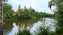
According to the plans of Harm Haslob, a north German landscape was created on a small scale in just five years of construction. Fifty thousand cubic meters of sand was blown up to form an artificial ridge two meters thick . This created an idyllic lake six meters deep on the east side of the cemetery. An earth wall as an artificial dike borders the cemetery towards the parking lots and the street. The visitor enters the facility through heavy iron doors that are modeled on a Deichtor.
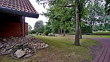
The chapel is built in the same red stone that was used for the old Stuhrer church from the 13th century and is used in many modern Stuhrer buildings. The roof of the chapel is almost completely drawn down to the ground and is reminiscent of the windswept farmhouses that crouch in the surrounding meadows of the Ochtum lowlands. It seems to be tied to the ground with heavy iron chains. Because of its location behind an earth wall, the chapel received the local name "Huus aft Diek" (house behind the dike).
The lightness of the all-white interior of the mourning hall contrasts with the architectural force of the building. Light falls through the open roof structure on the relief by the Oldenburg artist Max Herrmann (1908–1999) . The vertical lines and curved arches symbolize the step from earth to the hereafter. The floor consists of peat fire bricks laid in a checkerboard format. The mourning hall with gallery offers space for 180 guests and is heated with geothermal energy. At the inauguration of the chapel on May 4, 1990, the 120 kilogram bell rang for the first time in the roof structure.
particularities
A special feature of the Moordeich cemetery is the large number of “anonymous burials” . This means coffin or urn burials in communal graves. This form of burial had become necessary because the population was increasingly unable to save money for a regular burial site or because there were no relatives who could devote themselves to tending the grave. Members of other parishes in which no anonymous burials are carried out are also entitled to this form of burial at the Moordeich cemetery. For a fee, the name of a deceased can be immortalized on the bronze plate of a grave stele. The deceased do not have to remain completely "nameless". Of the 245 burials in 2013, 90 percent were anonymous burials. More than half of the deceased came from the Bremen district of Huchting.
See also
Web links
- Community of Stuhr, information on funeral services
- Information page of the Stuhr gallery tea room about the Moordeich cemetery
- Haslob Kruse + Partner Architects: Moordeich cemetery chapel
- Cemeteries in Huchting and Huchting-Stuhr
Individual evidence
- ↑ a b c Overview page of the Galerie-Teestube Stuhr , accessed on August 18, 2018
- ↑ Distribution of denominations and non-denominational in the Stuhr community
- ^ Umweltbetrieb Bremen, Friedhof Huchting , accessed on August 18, 2018
- ↑ Article in the district newspaper of March 8, 2014, accessed on August 18, 2018
Coordinates: 53 ° 2 ′ 10.2 ″ N , 8 ° 44 ′ 12 ″ E


