Gaab (river)
|
Gaab Gaab Rivier |
||
|
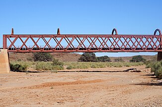
Gaab Rivier and railway bridge at Holoog (2018) |
||
| Data | ||
| location |
ǁKaras , Namibia |
|
| River system | Orange | |
| Drain over | Fish river → Orange River → Atlantic | |
| source | Small Karas Mountains 27 ° 20 ′ 12 ″ S , 18 ° 12 ′ 51 ″ E |
|
| muzzle | in the fish river coordinates: 27 ° 28 ′ 5 ″ S , 17 ° 40 ′ 33 ″ E 27 ° 28 ′ 5 ″ S , 17 ° 40 ′ 33 ″ E
|
|
The Gaab , also Gaap , is a rivier in the ǁKaras region in southern Namibia . The river rises on the southern edge of the Klein- Karasberg and flows in a westerly direction to the fish river . The confluence with the Fish River is about 15 km north of the Fish River Canyon . The Windhoek – Nakop railway line and the C12 main road cross the Gaab not far from the Holoog railway station .
annotation
- ↑ Note: This article contains characters from the alphabet of the Khoisan languages spoken in southern Africa . The display contains characters of the click letters ǀ , ǁ , ǂ and ǃ . For more information on the pronunciation of long or nasal vowels or certain clicks , see e.g. B. under Khoekhoegowab .
Web links
Commons : Gaab River - collection of images, videos and audio files
Individual evidence
- ^ Geographical Names
- ↑ a b Namibia Travel Map . Kunth-Verlag, Munich 2017, ISBN 978-3-95504-578-4 .
- ↑ Holoog stop on the map 27 ° 24'02 "S 017 ° 56'36" E

