
Gambissara
| Gambissara | ||
|---|---|---|
|
Coordinates: 13 ° 14 ′ N , 14 ° 19 ′ W |
||
| Region: | Upper River | |
| District: | Fulladu East | |
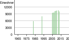
| Residents: | 9859 (2013)
|
|
|
||

Gambissara (spelling variant: Gambisara ; name variant: Sare Bonjo ) is a town in the West African state of Gambia .
According to a calculation for 2013, there are around 9,859 inhabitants, the result of the last published census from 1993 was 7,702.
geography
Gambissara is located in the Upper River Region District Fulladu East and is the second largest town in the Upper River Region after Basse Santa Su . The place, which lies directly on the border with Senegal , is about 13 kilometers southwest of Basse Santa Su.
The Gambissara Forest Park is located between Gambissara and Demba Kunda .
Economy and Infrastructure
The inhabitants, who form the main part of the Serahuli ethnic group , earn their income from pottery and woven goods . Some of the weaving mills are equipped with modern, wide looms.
Produced goods are preferred in the market in Basse Santa Su, the next larger town.
See also
Individual evidence
- ↑ Gambissara on bevoelkerungsstatistik.de (no longer available online, last accessed May 2013)