
Basse Santa Su
| Basse Santa Su | ||
|---|---|---|
 |
||
|
Coordinates: 13 ° 19 ′ N , 14 ° 13 ′ W |
||
| Region: | Upper River | |
| District: | Fulladu East | |
| Residents: | 11,859 (2013)
|
|

|
||
 |
||

Basse Santa Su , often just called Basse , is a town in the West African state of Gambia and is the seat of the Upper River Region administrative unit .
According to a calculation for 2013, around 11,859 inhabitants live there, the result of the last published census from 1993 was 9,265.
geography
The name of the place means something like "Compound above, on the hill" ( santo "[sic]" = above, su = compound). The highest point of the hill on which the site is located is at the coordinate: 13 ° 18 ' N , 14 ° 14' W .
The Basse Santa Su is 396 km (road) away from Banjul and is considered an important traffic junction in the eastern part of the country.
To the south of the village, around 1.5 kilometers away, is Mansajang Kunda on a road to Sabi . To the east of Basse is the neighboring town of Kaba Kama . Two bridges connecting Kaba Kama with Basse were renewed in 2011.

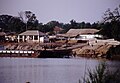
The river ferry dock on the north bank
The river ferry dock on the south bank


See also
Web links
Individual evidence
- ↑ Basse Santa Su on bevoelkerungsstatistik.de (no longer available online, last accessed May 2013)
- ↑ Rosel Jahn: Gambia. Travel guide with regional studies. With a travel atlas (= Mai's Weltführer. Vol. 29). Mai, Dreieich 1997, ISBN 3-87936-239-4
- ↑ Basse-Kaba Kama bridges undergo reconstruction ( Memento of the original from October 31, 2013 in the Internet Archive ) Info: The archive link was automatically inserted and has not yet been checked. Please check the original and archive link according to the instructions and then remove this notice. The Daily Observer of July 9, 2011