
List of surveys in Gambia

This is a list of surveys in the Gambia .
The shape of the Gambia is determined by the Gambia River , which flows from east to west. The river landscape is surrounded on both banks by low laterite hills . 78 percent of the Gambia lies between sea level and 20 m above sea level . Around 400 of the 11,420 square kilometers are above 50 m above sea level and form a sandstone plain with rocky, bare hills.
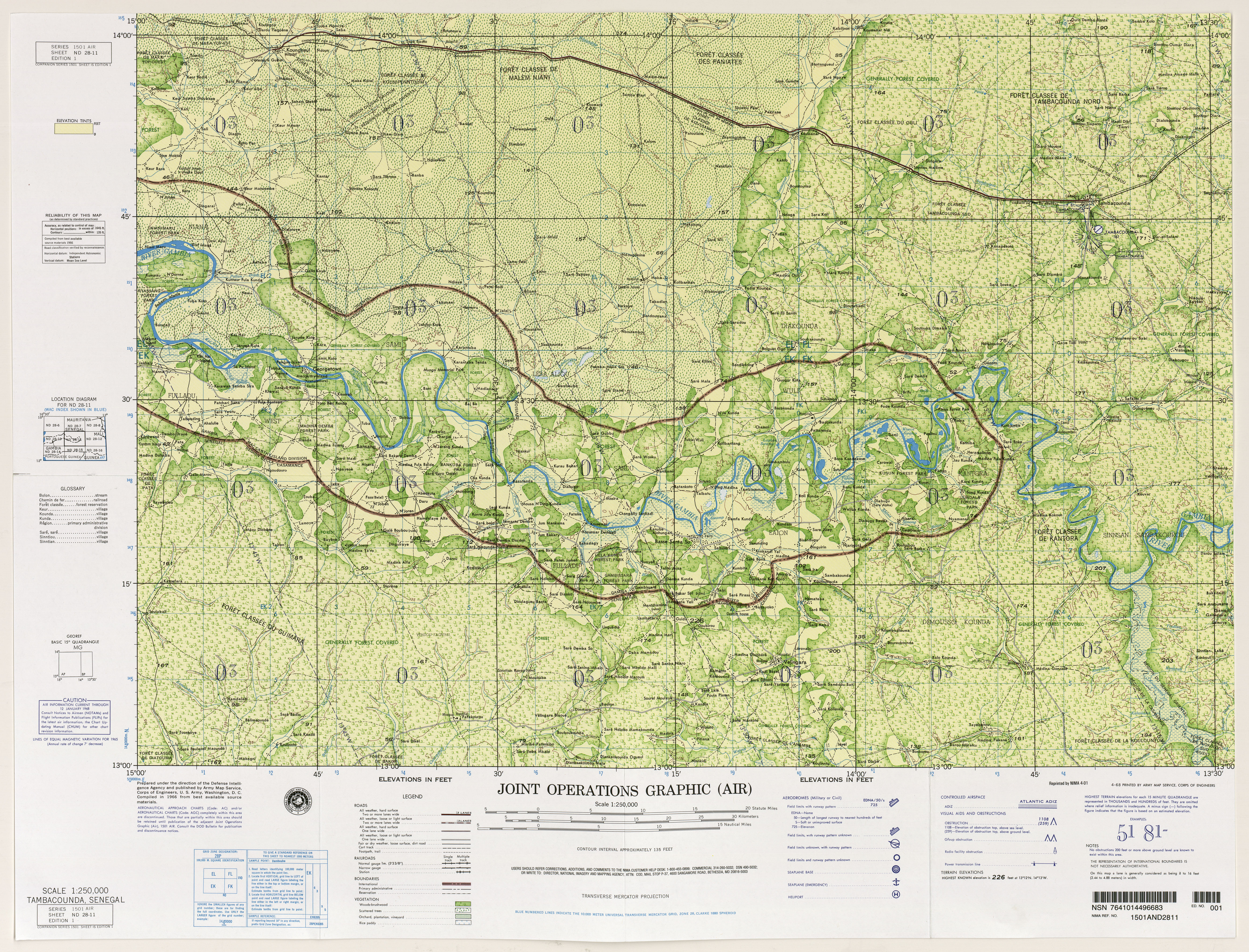
The highest point is at least 53 m above sea level. A rating based on information from 1966 map of the US National Imagery and Mapping Agency listed in Jah Kunda on the northern border ( 13 ° 31 ' N , 14 ° 11' W ) and in Nyamanari entirely in the east ( 13 ° 21 ' N , 13 ° 50 ′ W ), each directly on the border with Senegal , two points with an altitude of 174 feet, i.e. 53 m . The one at Nyamanari is also marked as the highest point in the country in The World Factbook . Both are within levels that are several square kilometers over 50 meters. On the basis of SRTM data , the peakbagger.com website calculated a highest point of 64 m between Sabi and the Senegalese Vélingara ( 13 ° 13 ′ N , 14 ° 10 ′ W ) on the edge of the Vélingara crater in 2019 . The highest elevation within a reddish sandstone plain, described by USGS and USAID , the page peakbagger.com and travel reports based on false Wikipedia information as 53 m high Red Rock does not exist according to research in the Wikipedia Commity.
The Gambia is the country in Africa with the lowest point. Worldwide only a few island states are even lower, see list of the highest points by country .
list
| height |
Surname | coordinate | comment |
|---|---|---|---|
| at least 53 m | the highest point | The Gambia reaches its greatest height on the border with Senegal without a defined hill rising from the sandstone plain | |
| 49 m | Kassang Hill | 13 ° 44 ′ N , 14 ° 55 ′ W. | Near the Gassang Forest Park . |
| 47 m | Balangar Hill | 13 ° 41 ′ N , 15 ° 22 ′ W. | Near the Belel Forest Park . |
| 47 m | nameless | 13 ° 18 ′ N , 14 ° 14 ′ W | The name of the place Basse Santa Su means something like " compound above, on the hill " ( santo "[sic]" = above, su = compound) in the Mandinka language |
| 38 m | Hill at Mansa Konko | 13 ° 28 ′ N , 15 ° 32 ′ W. | At the foot of a hill is the capital of the Lower River Region , whose name means "King's Hill ". |
| 37 m | Konkoba Hill | 13 ° 26 ′ N , 15 ° 49 ′ W. | A flat, sweeping hill in the Lower River Region near Tendaba . |
| 33 m | Cape St. Mary cliff | 13 ° 29 ′ N , 16 ° 42 ′ W. | On the coast from Bakau to Fajara , the cliff rises more than 20 meters above sea level. |
| 29 m | Mamayungebi Hill | 13 ° 31 ' N , 14 ° 35' W | Only a single hill with a name is shown on maps. The Gambia River loops around this hill in the Central River Region , the approximately 29 m high Mamayungebi Hill or Mamayungehi Hill . |
| 28 m | Bansang Hill (or: "Gamtel Hill" ) | 13 ° 26 ′ N , 14 ° 39 ′ W. | Hill near Bansang . The name "Gamtel Hill" probably comes from a cell phone transmitter of the Gambia Telecommunications Company (Gamtel). |
The free database for geographic objects, GeoNames , is still called the Alligator Rock . The database refers to a point around 11 m above sea level on the bank of the Gambia River ( 13 ° 22 ′ N , 14 ° 23 ′ W ). It is not clear what kind of object this database entry (of the type "hill" ) describes, a report on a British geological survey from 1927 called "Alligator Rock" a gravel bank in the river.
See also
Web links
Remarks
- ↑ Altitude information above sea level comes mostly from Google Earth
- ↑ “Compound” refers to the Gambian form of a settlement that is smaller than a village. Something like a homestead or a hamlet . See also Gambian Compounds. In: accessgambia.com. Retrieved August 1, 2019 .
Individual evidence
- ↑ a b Mala Ding S. Jaiteh, Baboucarr Sarr: Climate Change and Development in the Gambia: Challenges to Ecosystem Goods and Services . (PDF; 1.9 MB). Pp. 1-3. Elevation data based on: The Gambia 50,000 database 2003 topographic data. Department of Local Government and Lands.
- ↑ Global Environment Facility , United Nations Environment Program (Ed.): The Gambia's Second National Communication under the United Nations Framework Convention on Climate Change . (PDF; 3.6 MB). Banjul, November 2012, p. 32.
- ^ A b The World Factbook : The Gambia . Geography section and map . Retrieved July 30, 2019.
- ↑ West Africa, Joint Operations Graphic 1: 250,000: Map ND 28-11 Tambacounda, Senegal (11 MB). US National Imagery and Mapping Agency. Age of the card information given as 1966.
- ^ Gambia High Point. Elevation: 64 meters, 210 feet. In: peakbagger.com. Retrieved August 1, 2019 .
- ↑ S. Master, DP Diallo, S. Kande, S. Wade: The Velingara Ring Structure in Haute Casamance, Senegal: A Possible Large Buried Meteorite Impact Crater . In: 30th Annual Lunar and Planetary Science Conference , 15. – 29. March 1999, Houston, Texas ( online at researchgate.net ).
- ^ Ecoregion and Topography of The Gambia . USGS , USAID . Retrieved July 1, 2019.
- ↑ Red Rock, Gambia. Elevation: 53 meters, 174 feet. In: peakbagger.com. Archived from the original on July 22, 2017 ; accessed on July 30, 2019 (English). The page still referred to as Red Rock in the web archive has been corrected and a new highest elevation calculated from SRTM data , which is now simply referred to as the Gambia High Point .
- ↑ David Love: Around the Gambia . April 1, 2018, accessed August 1, 2019. A photo shows the reddish sandstone plain.
- ↑ Atamari: A Mountain That Does n't Exist . In: Wikimedia Foundation (ed.): Wp: kurier . July 27, 2019, accessed December 27, 2019.
- ↑ Kassang Hill. In: geonames.org. Accessed July 31, 2019 .
- ↑ Image of Balangar Hill. ( Memento of November 6, 2012 in the Internet Archive ).
- ↑ Erwin Bucher: On the way on the Gambia River, Upper River Course. 8-22 2nd 2012 . (PDF; 8.4 MB). Traveling with a sailing catamaran. In: red-harlekin.ch. Retrieved August 2, 2019.
- ↑ Rosel Jahn: Gambia. Travel guide with regional studies. With a travel atlas (= Mai's Weltführer. Vol. 29). Mai, Dreieich 1997, ISBN 3-87936-239-4 .
- ^ Martin Barnack, Gambian-German Forestry Project (GGFP): Mansa Konko. In: martinbarnack.de. Archived from the original on December 9, 2011 ; accessed on August 1, 2019 .
- ↑ Konkoba Hill. In: geonames.org. Accessed July 31, 2019 .
- ↑ Malanding S. Jaiteh: The Atlas of the Gambia. Landforms. In: Columbia.edu.
- ↑ Mamayungebi Hill. In: geonames.org. Accessed July 31, 2019 .
- ↑ Gambia. Scale 1: 350,000 . Vancouver, BC 2003, ISBN 1-55341-217-6 .
- ↑ ITMB Publishing Ltd Senegal & Gambia. Scale 1: 740,000 . Richmond, BC 2011, ISBN 978-1-55341-398-1 .
- ↑ Stephen C. Stringall, Dody Broyles: Gambia. International Travel Maps, Vancouver 2003, ISBN 1-55341-217-6 (map, 96 × 61 cm, 1: 350,000).
- ↑ Stephen Rice from London calls the hill that on his blog: Eastern Gambia. ( Memento of June 7, 2015 in the Internet Archive ) Retrieved June 2010. See the last photo under Eastern Gambia .
- ↑ Alligator skirt. In: geonames.org. Accessed July 31, 2019 .
- ↑ The Alligator Rock. In: geographic.org. National Geospatial-Intelligence Agency, Bethesda, MD, accessed August 1, 2019 .
- ^ William Gerald Groves Cooper: Report on a Rapid Geological Survey of the Gambia, British West Africa . HF & G. Witherby, 1927.
Egypt | Algeria | Angola | Equatorial Guinea | Ethiopia | Benin | Botswana | Burkina Faso | Burundi | Djibouti | Ivory Coast | Eritrea | Gabon | Gambia | Ghana | Guinea | Guinea-Bissau | Cameroon | Cape Verde | Kenya | Comoros | Democratic Republic of the Congo | Republic of the Congo | Lesotho | Liberia | Libya | Madagascar | Malawi | Mali | Morocco | Mauritania | Mauritius | Mozambique | Namibia | Niger | Nigeria | Rwanda | Zambia | São Tomé and Príncipe | Senegal | Seychelles | Sierra Leone | Zimbabwe | Somalia | South Africa | Sudan | South Sudan | Swaziland | Tanzania | Togo | Chad | Tunisia | Uganda | Central African Republic