
Tendaba
| Tendaba | ||
|---|---|---|
|
Coordinates: 13 ° 26 ′ N , 15 ° 48 ′ W |
||
| Region: | Lower River | |
| District: | Kiang Central | |
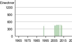
| Residents: | 426 (2013)
|
|
|
||
 |
||

Tendaba is a town in the West African state of Gambia .
According to a calculation for the year 2013, there are around 426 inhabitants, the result of the last published census from 1993 was 385.
geography
Tendaba, in the Lower River Region , Kiang Central District , is located directly on the Gambia River and about ten kilometers from the entrance to Kiang West National Park . The turnoff from South Bank Road at Kwinella is approximately three miles away.
Konkoba Hill is the name of the spacious 37 meter high hill at the coordinate: 13 ° 26 ′ N , 15 ° 49 ′ W near the village.
economy
Tendaba is known for Tendaba Camp , a camp that has been used for tourist purposes since 1972 .

The Tendaba Camp

See also
Individual evidence
- ↑ Tendaba on bevoelkerungsstatistik.de (no longer available online, last accessed May 2013)