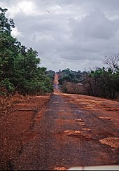
South Bank Road
The South Bank Road or Main South Bank Road ( German Süduferstraße ) is the most important trunk road in the West African state of Gambia .
description
The Gambia is a long, narrow state and follows the course of the Gambia River in West Africa from east to west for about 480 kilometers . There is a strip of land on either side that is 6 to 26 kilometers wide. The river used to be the main route of transport in this region. Until the mid-1980s there was a larger passenger ferry - the Lady Chilel Jawara , which sailed the river. When it sank, long-distance traffic shifted completely to South Bank Road.
South Bank Road connects Kombo St. Mary Area in the coastal region with all parts of the country up to the largest city Basse Santa Su in the east. On the coast are the capital Banjul and the largest city Serekunda , which is the economic center of the country.
The 29 kilometer long Serekunda – Mandina Ba section was modernized in 1998.
There is also the North Bank Road on the north bank of the Gambia River , which is now in significantly better condition than the South Bank Road.
Even the South Bank Road is not completely paved and shows considerable damage. It is now considered to be very difficult to drive on (as of July 2007). Alternatively, long-distance traffic accepts crossing the river twice by ferry. The Kharafi Construction Company began renovating the road in the second half of 2006. However, some of the diversions brought significant obstructions in the 2007 rainy season , for example the construction site at the Bulok Bridge became impassable in August 2007.
course
The main cities on the road are:
-
West Coast Region
- Serrekunda
- Wellingara
- Abuko with the Abuko Nature Reserve
- Lamin
- Yundum with the Banjul International Airport
-
Busumbala
- Between these two cities there is an important road in a south-westerly direction to Gunjur .
- Brikama
- Madina Ba , from here a main road south to Ziguinchor in the Senegalese region of Casamance .
- Kuloro
- Pirang
- Faraba Banta
- Sotokoi
- Bulok Bridge
- Bulok
- Sutusinjang
- Bessi
- Somita
- Sibanor
- Bwiam , this is the Bwiam General Hospital
- Sanajor
- Kalagi
- Brumen Bridge
-
Lower River Region
- Sankandi
- Dumbutu , there is a turnoff to Kiang West National Park .
- Wurokang
- Kwinella , there is a junction to Tendaba .
- Bambaka
- Nema
- Kunong Maria
- Nema Kuta
- Genieri
- Kaiaf
- Soma , this is where the Trans-Gambia Highway , known in Senegal as Transgambienne or N 4 , crosses the South Bank Road . The Trans-Gambia Highway connects northern Senegal with the southern Senegalese Casamance with the help of a ferry connection between Farafenni on the north bank and Soma . It has long been planned that a bridge will cross the river here. That is how long a river ferry has to maintain the north-south connection.
- Karantaba
- Dongoro Ba
- Pakali Ba
- Sofanyama Bridge
-
Central River Region
- Choya
- Dalaba
- Kumbaney
- Jarreng
- Sotokoi
- Kundang
- Jakhaly
- Madina Umfally
- Brikama Ba
- Taifa Saikou
- Fula Bantang
- Yero Beri Kunda
- Sankulay Kunda here it goes to Janjanbureh , where the North Bank Road meets the South Bank Road.
- Bansang
- Bantanto
-
Upper River Region
- Bakadaji
- Hela Kunda Bridge
- Hela Kunda
- Sotuma Sere
- Sotuma Bridge
- Canoe
- Allunhari
- Basse Santa Su , here a main road goes south to the Senegalese city of Vélingara .
- Kaba Kama
- Mansajang Kunda
- Chamoi Bridge
- Chamoi
- Sare Alpha
- Sare Alpha Bridge
- Sudowol
- Fatoto , this is where the North and South Bank Road merge about ten kilometers before the end of the country.
Individual evidence
- ↑ OPEC Fund for International Development ( Memento of the original from October 13, 2007 in the Internet Archive ) Info: The archive link was inserted automatically and has not yet been checked. Please check the original and archive link according to the instructions and then remove this notice.
- ↑ State of Mandinaba-Soma Road , Foroyaa , Aug. 13, 2007, via Allafrica.com
literature
- Cartes ITM: Gambia Map , Estate Publications, 2003, ISBN 1-55341-217-6
- Senegal & Gambia. Exact contour lines, elevation layer relief, GPS-compatible, classified road network, graticule and location index . Reise Know-How Verlag Rump, Bielefeld 2004, ISBN 3-8317-7123-5 , ( Reise-Know-how - World mapping project ).


